| BMW Garage | BMW Meets | Register | Today's Posts | Search |
|
|
|
 SUPPORT ZPOST BY DOING YOUR TIRERACK SHOPPING FROM THIS BANNER, THANKS! |
|||||||||
Post Reply |
|
|
Thread Tools | Search this Thread |
| 07-16-2011, 05:59 PM | #1 |
|
Lieutenant Colonel
 953
Rep 1,910
Posts |
Johnstown, PA: May 31, 1889
On May 31, 1889, a major rainstorm caused significant flooding in downtown Johnstown, Pennsylvania—and, at 3:10 PM, the earthen South Fork Dam at Lake Conemaugh gave way, allowing 5 billion gallons of water to come crashing 14 miles down the mountain, destroying the city altogether. At least 2,209 people lost their lives, making it the worst flood disaster in U.S. history.
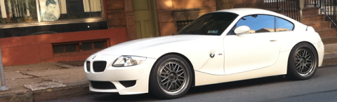
I'd been to the site of the South Fork Dam and Flood Memorial in March 2010 (see Chelsea & The Johnstown Flood). Later, in reading David McCullough's The Johnstown Flood, I realized how much more there was to the story than I had realized. It was time to return. As always, getting there proved to be quite interesting as well. After firing up the BMW Z4 3.0i at a ridiculously early hour, I motored out Interstate 70 and the Pennsylvania Turnpike to Route 56. Near Pleasantville, PA, I passed a sign that indicated there was a covered bridge to the west and another one to the east. In the process of finding both of these, I also encountered a third—all within the space of a few miles. Ya gotta love Pennsylvania. 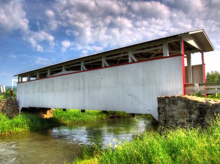    A few miles on the other side of Pleasantville, I found this glorious homage to the gas stations of days gone by. And, yes, that's a complete, working 1939 Ford Deluxe Tudor Sedan. Note the price for gas: You don't have to go back to pre-war days to remember gas at 29¢ a gallon (as Unity and I well know…)  In the middle of nowhere, on Dunkard Hollow Road, this home has seen better days—all that remain are the fireplace and chimney, foundation walls, and—naturally—the Ubiquitous Rural Satellite Dish (or URSD for future reference).  Soon enough I arrived at what had been Lake Conemaugh. Built by rich businessmen from Pittsburgh, including Andrew Carnegie, Henry Clay Frick, and Andrew Mellon,the South Fork Fishing and Hunting Club thrived during 1880-1889.   This is the main clubhouse, then and now. The wing on the left side in the original photo is long gone, but the rest has survived surprisingly intact, especially given its many uses since the club disbanded following the flood. The clubhouse is now owned by the National Park Service and is open to visitors in the summer. You might notice, incidentally, that there is no sign of the lake in front of the clubhouse. Instead, the banks of the lake and the lake bottom itself are home to the small village of St. Michael. The lake, having crashed downhill for 14 miles to Johnstown, continued along the Conemaugh River, joining the Allegheny River northeast of Pittsburgh, then combining with the Monongahela at Pittsburgh to form the Ohio River, flowing into the Mississippi, and finally the Gulf of Mexico. One might presume that the lake water subsequently evaporated into the atmosphere, formed to rain, and made its trip all over again—probably hundreds of times since 1899, but hopefully with less drama.   On May 29, 2 days shy of the 122nd anniversary of the disaster, numerous reenactors were on hand in full costume at the clubhouse, despite the blazing heat.   A number of the club members' "cottages" still stand, including the Queen Anne-style Moorhead House, with 17 rooms. You have to look carefully, but this is indeed the same place, photographed from different angles.   As I related in my earlier story, the changes made to the South Fork Dam by the Club made it ridiculously unsafe, even by the lax standards of the time. In particular, the drain pipes had been removed and the small spillway blocked with steel mesh fences, to prevent the stocked fish from escaping downstream. Consequently, there was no way to control the level of water in the lake… Following the 24 hours of hard rain, when the rising waters of Conemaugh Lake reached the top of the earthen dam, they quickly eroded its center and unleashed the aforementioned 5 billion gallons (20 million tons) of water. The lake took 40 minutes to empty, and the wall of water racing down the Little Conemaugh River was as much as a half mile wide and as high as 70 feet, traveling at roughly 40 mph. Estimates suggest that it carried the force of Niagra Falls. The water tore down everything in its path, including trees, railroad tracks, and a huge stone railroad viaduct. The viaduct managed to withstand the impact for perhaps 10 to 20 seconds before exploding apart. Remarkably, the first significant town along the path, South Fork, was largely spared. The next town, Mineral Point, was another story. This is Front Street, today, which sits immediately on the northern bank of the Little Conemaugh. On May 31, 1889, the entire town of 30 homes and a sawmill was spread out along Front Street; all were obliterated in seconds by the flood waters. As David McCullough described it, "The town was simply shaved off, right down to the bare rock." All but 16 of the 200 residents survived, however, having long since moved to higher ground before the dam gave way.   Next up was East Conemaugh, a major railroad town in 1889 and still active today. Much of the town sits on a hillside, safely away from and above the river. A passenger train from Pittsburgh and several other trains had stopped here because of rail damage farther upstream. A repair crew from the town was inspecting damage to the tracks when they heard the massive floodwaters crashing down the mountain. All they could see, however, were the tops of trees suddenly bending flat in the distance. John Hess, the engineer, immediately reversed his work train back down the mountain as fast as it would go—and tied the train's whistle-rope down so that it sounded continuously. His quick action alerted the town below, with residents and numerous railroad passengers running for the hillside. As a result, deaths were far fewer than might have been the case. Engineer Hess and his crew also made it to safety, with mere yards to spare. The flood swept the railroad depot off the map, including a brick roundhouse, approximately 30 80-ton locomotives (one of which was later discovered more than a mile downstream), hundreds of passenger and freight cars, and more than 100 houses. Today, the railroad is still a significant presence in East Conemaugh, and much of the town survives, but it's difficult to imagine what the lower part of town once looked like.    Woodvale was next in line, and it received no warning. In minutes, 314 people (one-third of the total population) and all 255 houses had been swept away. And then came Johnstown, already with several feet of floodwater covering the streets, a result of the pouring rain over the prior 24 hours. The waters from Lake Conemaugh came roaring down the Little Conemaugh River, through the notch in the mountains in the upper left portion of this photo. As they swept across Johnstown, destroying nearly everything in their path, they crashed into the mountain I was standing on for the picture, and rebounded back into town and back up the Little Conemaugh and Stony Creek (seen on the right).  Here's a close-up of the Little Conemaugh as it enters Johnstown. Note the flood walls bordering the river, placed there by the Army Corps of Engineers following the calamitous flood of 1936. 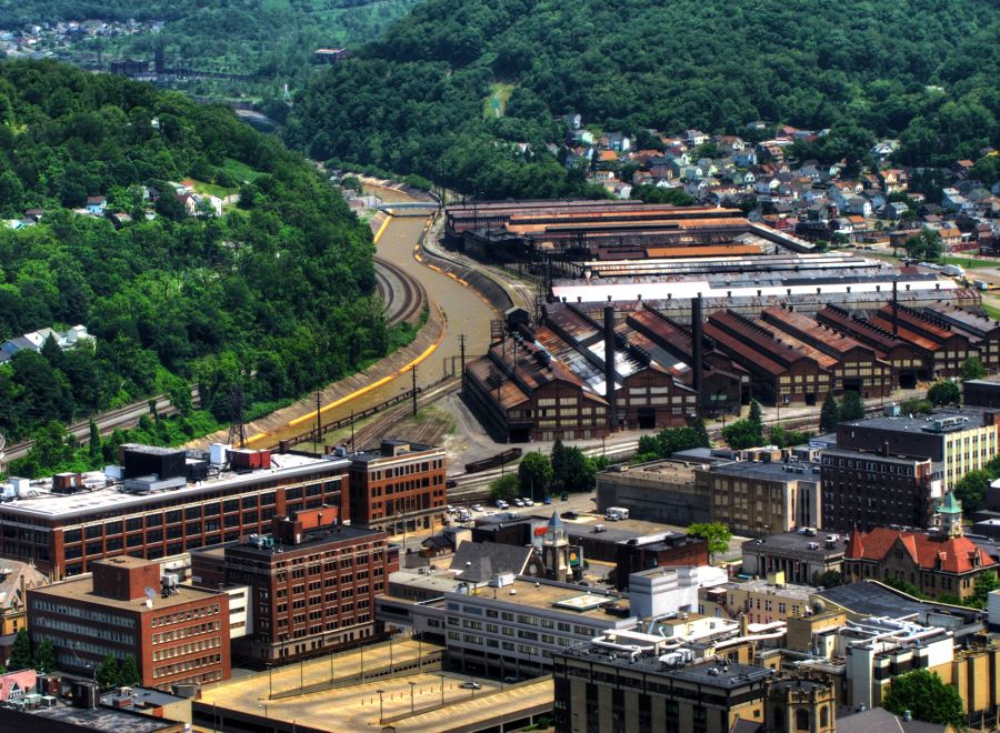 Similarly, Stony Creek has been widened and flood-walled.  The First Methodist Episcopal Church somehow withstood the force of the torrent, splitting it in two and helping to shelter a number of buildings in its wake. As evident from this 1889 photo, however, virtually all of the low-lying parts of Johnstown were washed away entirely. (Period photos courtesy of the Library of Congress.)   As the waters rebounded, collected, and began flowing again, they pushed a massive pile of houses, stores, people, and animals downstream to the Pennsylvania Railroad Stone Bridge, which was built 2 years earlier. With much of the water's force dissipated by its collision with the mountain, the bridge held. The bridge and collected debris acted as a dam, trapping the flood and leaving Johnstown under 20 or more feet of water. Tragically, many of the coal stoves used for heat back then were overturned as the houses were torn off their foundations, igniting numerous fires in the wreckage. This artist's painting of the scene at the bridge is perhaps a bit overwrought—but probably not by much. At least 80 residents were trapped in their burning houses at the bridge. 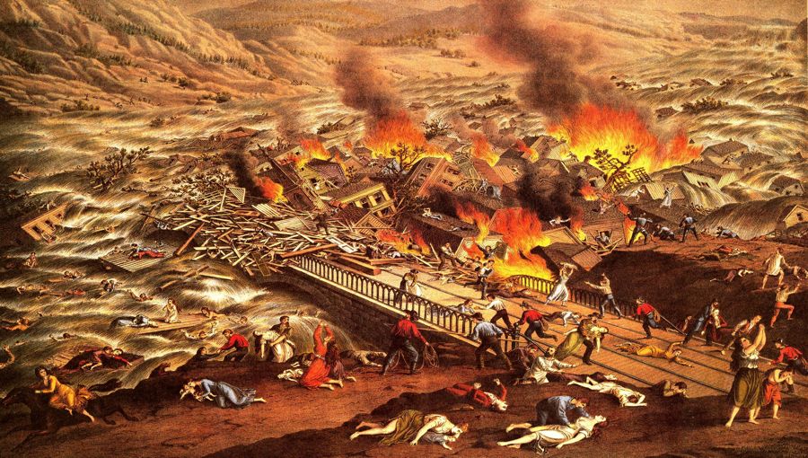 These photos, taken a few days later when the water had receded and rescue efforts were underway, show the utter devastation of the city.     There are also photographs of the victims, of all ages, trapped under mud, rubble, trees, and so on. Some are fakes, but all too many are clearly real—and I will spare you the sight. The Johnstown Flood Museum has many family portraits, such as this one, on display. In this instance, the parents survived, but all of their 7 children were lost.  This is one of the more famous pictures of the flood's aftermath. Remarkably, all of the family members survived.  In this photo, the Stone Bridge is in the distance, along with the heavily damaged Cambria Iron Works, which prior to the flood was the largest steel mill outside of Pittsburgh and produced more output than Carnegie Steel. The Cambria Works would return to production but would never regain its former stature.  Rescue efforts were immediate. The survivors of the flood worked tirelessly to free those trapped in the wreckage, despite having lost their own homes and not knowing if their family members were alive. Clara Barton, then age 67, arrived within days and established an emergency hospital and accommodations for the workers. The remaining buildings quickly became morgues, with lines of survivors waiting to view the victims, in the hopes (and fears) of learning the fate of their missing loved ones.       The Stone Bridge still stands across the Conemaugh River. Its appearance has changed somewhat, due to concrete reinforcing in 1929.  The downtown area is scenic once more, with a mix of a very few of the old, pre-flood buildings and many later ones. The Franklin Street Bridge in this photo replaced one washed away by the 1936 flood. (All told, Johnstown has been flooded 21 times between 1808 and 1977.)  Andrew Carnegie donated the money to build a new town library in 1892, which is now the home of the Flood Museum. Over the course of his lifetime, Carnegie donated the equivalent of $4.3 billion for various philanthropic projects. In addition, he and the other members of the South Fork Fishing and Hunting Club formed the Pittsburgh Relief Fund to aid flood victims—but to avoid liability for the flood, none of the members ever spoke publicly of the club or the disaster. Through this and other strategies, the members were never held responsible for the flood, despite the club's utter negligence with the dam and lake.  Not surprisingly, many new churches were built to replace those lost in the flood—and to serve as a place for prayers for protection against future disasters. The first of the churches shown here is First Methodist Episcopal, the lone survivor.   The "Grand House" building, pictured here, was once the home of the Johnstown Tribune. The front and side walls of the structure survived the flood, as did the BGS&G Building to the right, which was originally the Moses Tailor Shop. A number of the downtown buildings withstood the force of the flood as a result of being sandwiched together. Ironically, at the same time that the South Fork Dam was giving way, the editor of the Tribune, George T. Swank, was writing that "It is idle to speculate what would be the result if the tremendous body of water … should be thrown into the already submerged Conemaugh Valley." He survived, holed up on the roof of the BGS&G Building, and went on to write a captivating (if horrifying) first-person account of the catastrophe.  Alma Hall is famous for having sheltered 264 people during the flood, despite the first two stories being under water. One child was born in the building during the long night. 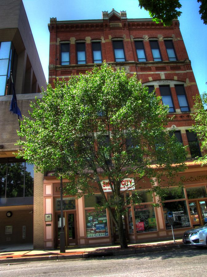 The original city hall, seen standing alone in some of the historic photos above, was too badly damaged to be rebuilt. This is its replacement. If you look carefully, you'll see three small markers arrayed vertically along the right-hand side of the building. The top one indicates the level of water during the 1889 disaster (21 feet). The next one down (17 feet) shows the height of the 1936 inundation. Following this second devastating flood, President Franklin Roosevelt ordered the Army Corps of Engineers to eliminate flooding by building channels through Johnstown for the Little Conemaugh, Stony Creek, and Conemaugh Rivers. The results worked perfectly—until 1977, when a "once in 500 years" torrent struck Johnstown, killing 85 people. The third marker (8.5 feet) shows the level in 1977.   If you're thinking of visiting Johnstown, please check the weather forecast. I had two more flood-related stops to make on this tour, with the first being Cambria City, immediately downstream of Johnstown. It was spared the worst of the flooding, owing to the dam created by the Stone Bridge, but it nonetheless was heavily damaged. Once home to 11,000 steel mill workers and others, it is the site of at least 10 large Catholic and other churches. Sadly, its current population of 1,000 is not enough to support so many cathedrals, and a number were closed in 2009, including the two pictured below:   My final Johnstown stop was Grandview Cemetery, on the hills overlooking the city and the final resting place of the flood victims. It was the perfect place to reflect solemnly on the tragedy.  As noted, at least 2,209 individuals died in Johnstown on May 31, 1889. Of this total, the remains of 777 were never claimed or identified. These unfortunate souls are buried in unmarked graves in a special section known as the Unknown Plot.  Well, patient readers, if you've stuck with me this far, perhaps you'll be willing to learn about the rest of my sojourn into Pennsylvania. It, too, was of great interest, and it was thankfully free of any further signs of past disasters. It began with the discovery of this handsome pair of Harley-Davidsons. Beautiful paintwork? Check. Glorious classic styling? Check. Excellent handling? Hmmm, better check that skinny front tire!  The city of Gallitzen, PA features the Gallitzen Railroad Tunnels, the first of which was constructed in 1851-1854 to carry the Pennsylvania Railroad through the Allegheny Mountains. Two of the three tunnels are shown here, with the "Allegheny" Tunnel on the right and the "Gallitzen" Tunnel on the left. The former was widened to two tracks in the 1890s and then further enlarged to handle double-decker freight in 1993. At that time, the faithful old Gallitzen Tunnel was taken out of service.   Continuing the railroad theme, the famous Horseshoe Curve lies a few miles to the east, midway between Gallitzen and Altoona. It, too, was built in 1854 and has been in continuous operation ever since. The completion of the Pennsylvania Railroad made the earlier Allegheny Portage Railroad and Pennsylvania Canal obsolete. The Horseshoe Curve was so important to U.S. railroad operations that Nazi secret agents attempted to destroy it during World War II as part of Operation Pastorius.  A long, steep climb of 194 steps brings visitors to the inside of Horseshoe Curve—in my case, just in time to see a westbound passenger train go by. Out of breath, having raced upwards to catch the picture, I looked around and realized that there is a small funicular railway to carry passengers to the top…   A pair of tunnels allow streams to pass underneath the earthworks supporting Horseshoe Curve. This is the one for Kittanning Run.  By now it was late in the day, and I began to think of where to spend the night. The not-always-trusty Zumo pointed me in the direction of Clearfield, PA—but my progress was slowed by a steady stream of photo-worthy places, including this scenic farm…  …this beautiful old house, in excellent condition, that overlooked...  …this collapsed barn, which was near…  …Curwensville Lake, and …  …an empty road, bordered by abandoned barns. It's a wonder that I ever arrive at any planned destination. To get to work on time, I have to leave my camera at home. 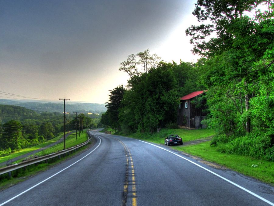 After a restful night in Clearfield, I explored the town briefly before continuing on. The West Branch of the Susquehanna River looked tranquil in the early morning light, and there was no shortage of interesting old homes to admire.    My route was unrelentingly rural, and you could pretty much stop anywhere to get pictures. You know it's a bad sign when they're using plywood to reinforce a bridge! (Don't try this at home, kids; I'm a professional…)   The West Branch Susquehanna is another one of those places where you'd like to pull up a chair and just admire the view for an afternoon.  Just as I was thinking that I hadn't seen a covered bridge in several hours, the McGees Mill Bridge appeared. It was built in 1873 and renovated in 1994 after a heavy snowfall caused the roof to collapse. It's the only remaining covered bridge over any branch of the Susquehanna River. 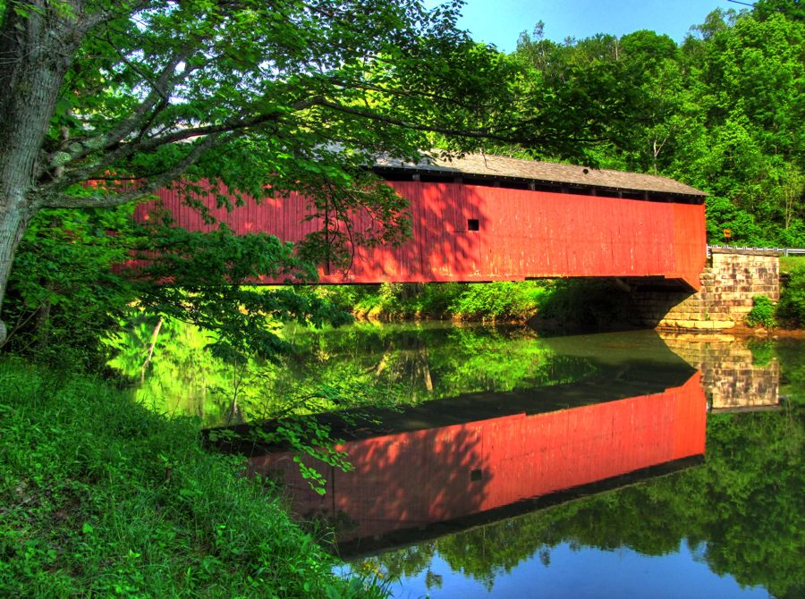 The old and the new, each with its own singular beauty.  In the almost nonexistent town of Arcadia, I found two abandoned churches, separated by only 100 feet or so on the same hillside. Two others, still active, were just down the road. How a community with a total of maybe one or two dozen houses could support four different churches is beyond me, but there they were.   Not all of the roadside attractions were Harleys, churches, homes, or covered bridges. This pair o' rods was intriguing. The dirt-track racer looked to be fun (I suggest earplugs) and featured a nice new humongous exhaust system. It was the lowest '32 Ford variant I'd ever seen. I have no idea what the reddish-orange street rod is. Any guesses out there, readers?? 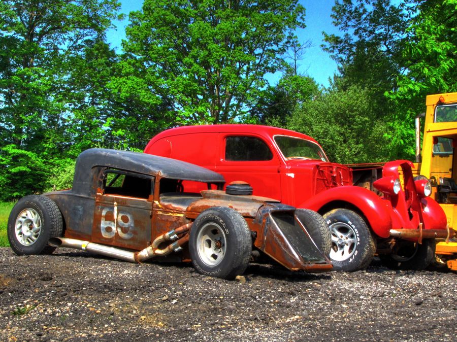 My route next took me through Indiana, PA. (I know, it's confusing; try to keep up!) This statue on the courthouse lawn looked familiar as I drove by. Backtracking, I discovered that it's the famous actor and World War II pilot Jimmy Stewart, who was born here in 1908.  At the top of this implausibly steep set of steps is the house that Mr. Stewart grew up in. It was easy to picture him running out of the front door and sliding down the railing to go into downtown Indiana, perhaps to watch a silent film.   I didn't see much in the way of interesting old Baptist churches on this trip (sorry, Cathy and Kim!), but I couldn't resist the Bethel Presbyterian Church, still standing proud after 223 years of service.  Sadly, my rural road trip was coming to an end, and it was time to hit the Interstate back to Catonsville. I enjoyed the remaining scenes as long as possible.  There seemed to be hundreds of these gigantic fork lifts lined up, as if to welcome a newly married military couple to walk in honor under their raised "swords." Make a note: You never get to see things like this along the Interstate. 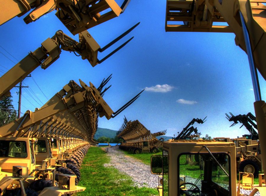 Once on Interstate 70, I found that, ironically, the highway was gridlocked at Hancock, MD as far as the eye could see. I proceeded to take the World's Longest Detour, first venturing far north of 70, then well south, only to return back north, etc., as I zig-zagged by way eastward. Quick it was not, but my random and desperate efforts to avoid traffic did take me by a few more photo-op's, with this one being my favorite: 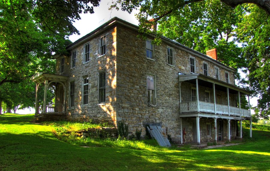 Eventually I made it back home, after 2 full days of Z4 touring and with 620 additional miles on the odometer, having averaged 28 mpg. As always, the BMW ran faultlessly and was great fun to drive briskly through the mountains and valleys. It was a terrific outing, full of history, beauty, and considerable solemnity. So what's in your back yard? Get out there and drive, photograph, return, and post! Rick Last edited by Rick F.; 09-22-2015 at 04:36 PM.. |
| 07-16-2011, 09:46 PM | #3 |
|
First Lieutenant
 
21
Rep 352
Posts |
Rick,
Wonderful history lesson of Johnstown with beautiful photos to boot. It's amazing what they were able to overcome in rebuilding the town, such devastation is hard to imagine. Good to see you getting some "down" time...  The photo of the fork tractors kind of baffles me, as if there was any type of hydraulic failure they could come crashing down. Thanks again for sharing! Dave
__________________
 OEM Strut Brace / UUC SSK / Zeck CDV / Clutch Stop / ZHP Shift Knob / Stubby Ant / Top Covers / Dinan K&N / M Seats / SP / PP |
|
Appreciate
0
|
| 07-17-2011, 08:26 AM | #4 |
|
Lieutenant
9
Rep 452
Posts |
Thanks for sharing this, Rick. I did a similar trip years ago while living in Pittsburgh and owning a series of MG's. Something about sports cars, the summertime and touring interesting places...
__________________
Vibra Technics engine mounts / Rogue trans mounts / Stoptech brakes / original owner
|
|
Appreciate
0
|
| 07-17-2011, 10:43 AM | #5 |
|
More of this than that!

29
Rep 817
Posts |
Wow...those floods were devastating.
Thanks once again for a very entertaining trip! 
__________________
 '06 Z4 3.0i Jet Black/ Biege/Black Leather / Premium Package / DICE Silverline DUO / Stubby Antenna / Matte Black Grill Ultimate Cup Holder x2 / Gaptech RCH+ / First Aid storagebox x2 / Acrylic Wind Deflector |
|
Appreciate
0
|
| 07-17-2011, 03:48 PM | #6 |
|
Lieutenant Colonel
80
Rep 1,663
Posts |
As always thanks for the beautiful posts Rick. Sat down with the g/f and enjoyed all your photos and stories.
__________________
|
|
Appreciate
0
|
| 07-28-2011, 09:47 PM | #7 | |
|
Lieutenant Colonel
953
Rep 1,910
Posts |
Quote:
Okay, I'm still trying to figure out what "<3's" means, but I'll take it as a compliment of some sort--thanks! Rick F. |
|
|
Appreciate
0
|
| 07-28-2011, 09:49 PM | #8 | |
|
Lieutenant Colonel
953
Rep 1,910
Posts |
Quote:
Thanks much! As always, I'm very glad that you enjoyed the write-up and photos. I hadn't thought about the consequences of hydraulic failure on the forklifts--yikes...  Rick |
|
|
Appreciate
0
|
| 07-28-2011, 09:52 PM | #9 | |
|
Lieutenant Colonel
953
Rep 1,910
Posts |
Quote:
Glad you enjoyed the trip report. And you're right, there is something special about good weather, sports cars with the tops down, and driving for the sheer fun of it. As for MG's, I've only ever owned one. It was a 1964 MG Midget that I bought used in 1969 for $450. Although it was only 5 years old, it was already clapped out--but I loved that car, more so than any vehicle since. (Of course, since I'm 6'6" tall, I also cursed it every single time I got in or out of it...) Rick F. |
|
|
Appreciate
0
|
| 07-28-2011, 09:55 PM | #10 | |
|
Lieutenant Colonel
953
Rep 1,910
Posts |
Quote:
Yep, I just can't imagine what it must have been like to have so much water crashing into town that buildings were instantly knocked down, houses pushed off their foundations, and your neighbors floating by on debris, calling for your help. Glad you enjoyed the report! Rick F. |
|
|
Appreciate
0
|
| 07-28-2011, 09:56 PM | #11 | |
|
Lieutenant Colonel
953
Rep 1,910
Posts |
Quote:
As I've said before, hang onto that g/f of yours! Rick |
|
|
Appreciate
0
|
| 11-03-2011, 08:08 PM | #12 |
|
Iron Ring
11
Rep 316
Posts |
Sad, sad event. Beautifully told. Great photos!
DaveL Toronto
__________________
DaveL///Toronto. http://www.ironring.ca/
My wife's cars: Had a few... I'm the Navigator, capable of getting us lost at any time! Drives are longer! |
|
Appreciate
0
|
Post Reply |
| Bookmarks |
|
|