
| BMW Garage | BMW Meets | Register | Search | Today's Posts | Mark Forums Read |
|
|
|
 SUPPORT ZPOST BY DOING YOUR TIRERACK SHOPPING FROM THIS BANNER, THANKS! |
|||||||||
Post Reply |
|
|
Thread Tools | Search this Thread |
| 08-20-2013, 01:06 PM | #1 |
|
Lieutenant Colonel
 946
Rep 1,910
Posts |
Mineral Springs, Sanatoriums, & Dirty Dancing: A Then and Now Z4 Tour of Virginia
Dr. Henry Huntt was the physician to Presidents James Monroe, John Quincy Adams, and Andrew Jackson. He was an impassioned proponent of the health benefits of mineral spring water, crediting the Red Sulfur Springs resort with curing his lung disease in July 1837. Fourteen months later, however, he was dead and buried.
The hills of southwestern Virginia are a wonderful place to relax, enjoy the outdoors, go sightseeing, and try the mineral springs. In the late 1700s and most of the 1800s, people flocked to the resorts and spas around Roanoke for exactly these reasons. Today, however, only a handful of these places survive. What happened to the others? I set off to find out on July 24, driving my always-eager BMW Z4 3.0i roadster. The first order of the day was to travel the 287 miles from Catonsville, MD to Lexington, VA. With the dash registering 32 mpg at 75 mph, it didn’t take long. With clear weather predicted for this area, I had carefully washed and polished my Z4 in the hopes of getting some great BMW photos. Naturally it was raining steadily by the time I approached Lexington!  First stop was an 1803 brick house that was the first and only home owned by Thomas Jonathan “Stonewall” Jackson. He lived here with his wife Anna from 1858 to 1861, when he resigned from the U.S. Army and joined the Confederate forces as a Colonel. (Their daughter Julia was born in 1862, shortly before Jackson’s death.) His house in Lexington is now a museum.   Other, nearby houses in Lexington were rather more elaborate than the Jacksons’ home. The first is now a law office, and the second serves as the headquarters for the Rockbridge [County] Historical Society.   Lexington is home to two major colleges: Washington and Lee University, and a military institute that shall remain nameless, since it is the arch-rival of my brother’s alma mater, Virginia Tech. Washington and Lee began operations in 1749 as Augusta Academy and was well on the way to going broke by 1795, when George Washington donated the then-extraordinary sum of $20,000 in stock. The grateful trustees changed the name of the school to Washington Academy. Today, that original endowment still reduces the annual tuition of each and every student by $1.87!   Following the Civil War, Robert E. Lee became president of the college and introduced a number of important changes, including the school’s famous honor system. After his death in 1870, the college was renamed Washington and Lee University. This is the Lee Chapel, where Robert E. Lee, his father “Light Horse” Harry Lee, and the other members of his immediate family are buried.  Inside, as well as out, the chapel looks very much the same as when Lee was president. The portrait of George Washington is the earliest known painting of the first U.S. President.    Following Lee’s death, his devoted wife Mary commissioned this statue of the General, resting on a camp cot on the battlefield. It’s a striking work of art, and the detail is extraordinary—for example, the weave of the light blanket is clearly visible in the marble.  The Lee Chapel also houses a museum in its basement that includes, among many other things, the exact contents of Lee’s college office on the day of his death. (No photographs allowed, unfortunately.) As I left the chapel, I found the burial spot of Lee’s beloved horse, Traveller, just outside the walls.    As I continued on old Route 60 westward, I discovered this 1955 Buick Roadmaster. It seems to have been waiting for service for quite some time…  The Maury River Friends (Quaker) Meeting House appeared in my peripheral vision, demanding a quick U-turn—and yet another photo, of course.  I had to park somewhere in order to take the photo above, and this driveway was convenient. Fortunately, no children were harmed in the making of this trip report.  This old structure was hiding behind some trees nearby. Was it a small barn? Or the simplest of houses? I couldn’t tell, although the windows on the front side made me suspect that someone used to live here.  My next goal was to find the ghost of Lucy Selina—which, in fact, I did. And I have photographic evidence to prove it. First, I located what’s left of the town of Longdale Furnace, including the house that had been built by Lucy’s master. It still looks a lot like it did in 1883. This 23-room mansion was the home of Harry Firmstone in the late 1800s and early 1900s and is now the Firmstone Manor Bed & Breakfast. The historical photos of the manor and surrounding area are courtesy of the B&B’s enchanting History of Firmstone Manor and the Hamlet of Longdale Furnace. It’s well worth a read. (Don’t miss the part about the founder’s son Edwin hanging himself from a tree and the discovery of his wife, who had been buried alive… Every community seems to have its little secrets.)   I’m not sure what the interior of the Firmstone Manor looks like these days, but it used to look like this, swords, pistols, and all!  But what about poor Lucy Selina, you ask? She started her life of service in 1827, received a major refurbishment in 1874, and was joined by another “working girl” nicknamed Australia in 1881. Huh? Oh, I may have failed to mention that Lucy Selina was the name of the town’s original iron furnace.  (What were you thinking?) (What were you thinking?)   During the Civil War, about 70 slaves were forced to operate the Lucy Selina furnace and produce huge quantities of iron for use in making cannons, ammunition, and other matériel for the Confederacy. One report indicates that the Confederate ironclad ship, the CSS Virginia (better known as the Merrimack) was made from iron produced by the Lucy Selina furnace. (The Currier & Ives print shows the CSS Virginia sinking the Union ship USS Cumberland.)  After the furnaces were purchased by William Firmstone (Harry’s father), numerous innovations and improvements were introduced, and the town of Longdale Furnace grew to roughly 5,000 inhabitants, most of whom were involved directly or indirectly with Firmstone’s business operations. Longdale Furnace became a classic “company town,” with company-provided housing, churches, doctors, etc. This was the Longdale Iron Company office, a log structure built in the late 1820s and expanded in the 1870s by Firmstone. The foundation ruins in the foreground were probably from the locomotive shop. The company ran its own narrow-gauge railroad for transporting iron ore, lumber, and coal to the furnaces and finished pig and bar iron to the market.  Although Lucy Selina’s original furnace stack was 37 feet tall, after the upgrades there were two 106-foot brick chimneys that were used until the company ceased operations in 1911. Most of the furnace buildings have since been dismantled, but the chimneys still stand today and appear to be in remarkably good shape. (The second chimney is covered by ivy and is only just visible in the upper right of my photo.) The brick machine shop shown in the historical photo still sits behind the chimneys, but it’s heavily overgrown and virtually invisible. The little bridge over Simpson Creek is also still there. But note how the trees and other vegetation have nearly obscured the entire area. You could drive by the chimneys repeatedly without ever spotting them. Long live the ghost(s) of Lucy Selina! 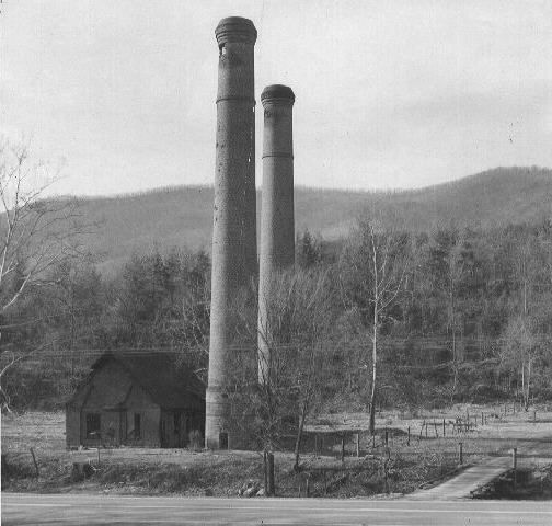  My next quest was to find the Iron Gorge, where the Jackson River carves a deep channel through the Horse and Rough Mountains. My first attempt led me to this Alamo-like building near the river. However, the path I’d identified using Google Maps was summarily blocked off by the CSX Railroad, which apparently preferred to avoid having tall, gawky photographers roaming around on their tracks. My second attempt succeeded, fortunately.   The nearby town of Clifton Forge got its name from an iron forge on the banks of the Jackson River. All that’s left of the operation is this stone furnace. From its top, you can get a good view of Rainbow Rock across the river.     Clifton Forge features three (count ‘em!) three Baptist Churches, just for Cathy and Kim, plus one veritable mansion. Note the substantial expansion of the Clifton Forge Baptist Church, compared to the old postcard.      As I was taking photos, a pleasant young woman stopped and told me that the large house at the end of this block is owned by a 90-year-old woman, who also owns the dilapidated, vine-covered little place behind my Z4. She also told me where to find the mansion, pictured above. You meet a lot of nice people in Virginia.  At 2½ stories, the Clifton Forge railroad station is a lot taller than most. It was built in 1902 and is still used by Amtrak and CSX (the successor to the famous Chesapeake & Ohio Railroad).  The Oakland Grove Presbyterian Church in Selma, VA was built in 1845, replacing an earlier log church. It stopped holding services in 1963 but is maintained in good condition by a nearby Presbyterian congregation. The church served as a Confederate hospital during the Civil War, and a number of soldiers are buried here, including twelve from a Tennessee regiment commanded by Stonewall Jackson.   For anyone seeking a nearly perfect road for motorcycling or driving, Route 220 between Covington and Hot Springs, VA certainly qualifies. It twists and turns up one mountain after another and offers a number of exceptional views as well. The best is of Falling Springs Falls, one of Virginia’s tallest waterfalls. This area had received a substantial amount of rain in the week before my visit, so there was quite a torrent cascading the 80 feet to the rocks below. (For perspective, note the young couple climbing down from the base of the falls.)  A short trail from the overlook leads you to this beautiful pool above the falls. Remarkably, the falls originate with several nearby underground springs in the Warm Springs Mountains, including one in Warm River Cave; there are no other tributaries.  Slightly farther along the trail, you reach the top of the falls. The water looked very peaceful and cool, and it was tempting to wade on in, given the heat of the day. But some things constitute Tempting Fate in such a major way that they just shouldn’t be done!  In an odd footnote to the Falling Springs Falls, I learned that this is not their original location. When Thomas Jefferson visited the falls in the 1770s, they were 200 feet high and much broader. A local fertilizer company, in its infinite wisdom, decided to mine the area around the original falls and diverted the stream to its current location. The first illustration of the original falls is from the Album of Virginia by Edward Beyer in 1858. The other two are from vintage postcards.    Route 220 also offered this view of Covington in the distance (and the opportunity to exercise the telephoto lens in the ol’ Canon SX40).   I started my tour of Covington in the historic Rosedale section, just across Dunlap Creek from the main city. It’s named after this brick Greek Revival mansion, Rose Dale, which was built by Thompson and Lydia McAllister in 1856-57. I couldn’t help noticing an incredible racket of some sort coming from the area across the creek. It turned out to be the massive Westvaco Paper Mill that dominates Covington—and which was built on land sold to the company by the McAllisters.  An even more imposing mansion sits just down the street. It was built in 1911 by Frank H. Hammond, Sr., who supplied the commissaries for the numerous coal mining companies in the area. It’s a Classical Revival style—and it just happens to be for sale, if you’re interested (and have $795,000 handy). The peek inside is courtesy of Fairfield Farms Realty.    From Rosedale, I set off to drive up Luke Mountain, in search of a view overlooking Covington. I was prompted by the old postcard shown below, but I soon discovered that tall trees and shrubs obscured the view down to the city.  When I reached Luke Mountain Road, I noticed what looked like a tall entrance gate with “Pen-Y-Bryn” chiseled into the granite. I didn’t think much about it as I drove up the long, winding road—but I later learned that William A. Luke, Sr. was the general manager of his family’s West Virginia Pulp and Paper Company (now Westvaco) in Covington, and he chose this mountain to build three magnificent estates for himself and his family, starting in 1917. This photo shows the first of the mansions, named Pen-Y-Bryn. (It, too, was recently for sale, with an asking price of $740,000 in a depressed 2010 housing market. Seems like a pretty good deal for 20 rooms, 6-car garage, pool, and 12,500 square feet…)  You’re probably thinking that I took this photo of Main Street in downtown Covington because of the brilliant red Corvette convertible in the foreground. Well, I admit that it looked really nice, but the subject of this photo is actually the small, nondescript, white building on the other side of the street.  Why bother? Because before the trip, I ran across this intriguing photo from 1946, showing a large crowd trying to buy food at the Covington A&P. It appears to be Spring, World War II has been over for nearly a year, and U.S. food supplies are becoming more abundant. So what was going on? I believe the lines at the store were a consequence of President Truman’s February 6, 1946 implementation of “Emergency Measures To Relieve the World’s Food Shortage.” Following the war, many European and other countries were facing the prospect of mass starvation, and Truman’s edict was designed to divert about 16 percent of U.S. food supplies to other countries. As a result, many American stores would run out of bread, certain meats, and other foods early in the day, leading to long lines of customers anxious to purchase groceries while they were available. (As it happened, the mostly voluntary efforts during 1946-1947 were inadequate to address the problems overseas. The subsequent Marshall Plan of 1948 proved far more successful.) 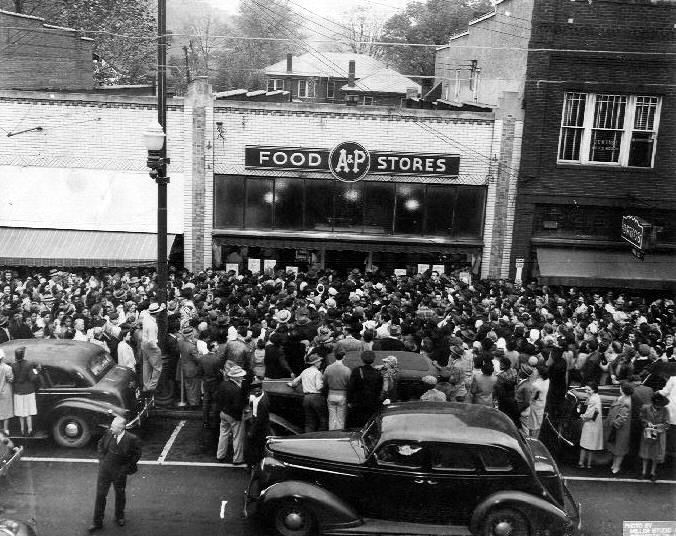 The Covington City Hall is just up Main Street from what had been the A&P, complete with this monument to soldiers of the Confederacy. It’s been around for quite a while, as shown in the postcard.   Covington seems to have had two railroad stations. This one is referred to as the “depot.” It sat unused and deteriorating for many years but has recently been partially renovated.    Just west of the depot is the “station.” Ironically, neither building is used for train travel; passengers must go to the Amtrak station in Clifton Forge.  My final stop in Covington was at the First Baptist Church, which has been serving its congregation since 1890. The odd black-metal contraption near the front steps appears to be a rather primitive elevator for wheelchair-bound churchgoers.  I made a detour to find Milton Hall, the English Gothic Revival home of William Wentworth Fitzwilliam (Viscount Milton) and his wife Laura Maria Theresa Beauclerk (Lady Milton). They had left England in 1872, when Viscount Milton’s epilepsy worsened, and they bought Callaghan’s Tavern in Virginia to live in with their children and servants. They moved in just before Christmas, 1873—and a week later the tavern burned to the ground as a result of New Year’s fireworks. They subsequently built Milton Hall and lived happily ever after—in this case, for only 3 years and 12 years, respectively, with both Lord and Lady dying at age 37. Milton Hall became a B&B in 1990, but as I approached the mansion I realized that it was now a personal residence. Oops! This is what it would have looked like if I’d been able to get a photo (Flickr image by gothicartlover).   In Edgemont, I suddenly found myself in what looked like a ghost town from the Old West (admittedly with a slightly art deco look in the middle).  From Covington, I picked up one of the routes from RoadRunner Magazine’s Roanoke Virginia Shamrock Tour. The more I drove their route, the more I became convinced that Editor-in-Chief Christa Neuhauser and her son Florian had selected the roads based entirely on the number of squiggles per inch that they saw on the map! No kidding, these were among the most consistently curving roads I’d ever come across. I didn’t try to determine the average number of corners per mile, but they certainly contributed to a great many smiles per mile! As I drove around this rural part of Virginia, I was struck by how many homes, farms, and businesses were closed and abandoned. Earlier, in downtown Covington, the majority of businesses were either closed or vacant. It all seemed more like West Virginia than the generally prosperous State of Virginia.  By late afternoon, I reached the Roaring Run State Park in Botetourt County and promptly set off to hike up to the Roaring Run Falls. It was a beautiful setting, with the trail crossing and recrossing the creek several times. There were quite a number of lesser waterfalls along the way.    No one was using this natural water slide, although it looked inviting. I could figure out how to start at the top, but I was a lot less sure how to get back to the trail from the bottom!  Finally, I found the main falls and enjoyed the cool breeze and scenery for half an hour before retracing my steps. As I was leaving, a number of teenagers (and their parents) arrived and happily hopped into the natural pool at the base of the falls, along with the family dog. 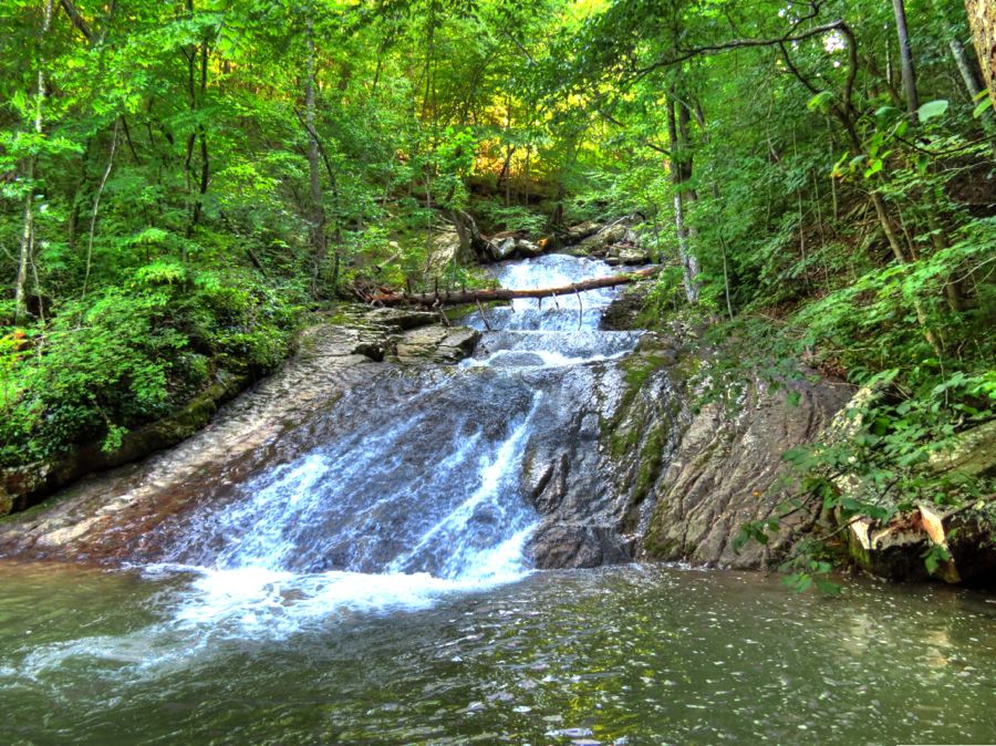 Another path led me to the ruins of the Roaring Run iron furnace, which operated from about 1832 to 1854.  I don’t usually wonder about the history of bridges as I’m crossing over them, but in this case it turned out to be significant. The Phoenix Bridge was prefabricated in Pennsylvania and started service in the late 1800s near Bessemer, VA for the Chesapeake & Ohio Railroad. In 1903, it was moved to its current location over Craig Creek as part of the C&O’s efforts to upgrade their rail lines and bridges. It carried light steam locomotive traffic until being reinforced in 1951 for heavier diesel engines. The Craig Valley Branch of the railroad was abandoned in 1959, and Botetourt County bought the bridge and converted it to automobile traffic in 1961. Who knew?   Railroad Avenue in downtown Eagle Rock has been flooded by the James River so many times that local residents have lost count. The best years of the Farm Supply Store have come and gone, but the 1899 Bank of Botetourt remains open and active to this day, despite having been almost entirely under water during the flood of 1985.   Eagle Rock was well on its way to becoming a ghost town after its lime manufacturing plant shut down operations. Then, the flood of 1985 seriously damaged the only bridge into town from Route 220, cutting off easy access to the outside world. And Virginia’s Highway Department had no plans to replace it. If you look carefully, you can see what little is left of the 1932 bridge in the distance.  You may have noticed that the photo above was probably taken from another bridge over the James River. The town lobbied long and hard and finally convinced the powers that be to build a new, flood-proof bridge into Eagle Rock. It seemed as convenient a spot as any for me to park and take pictures.  Especially since there was a wonderfully scenic wall o’ rock on the western shore of the James. Especially since there was a wonderfully scenic wall o’ rock on the western shore of the James.  By now it was after 7:00 PM, with sunset due in about an hour and a half. I had not yet made any arrangements for a place to stay overnight, and there was no cell service in this area. Moreover, the Z4’s fuel warning light had just come on. Accordingly, I drove off to find the lost ghost town of Lignite, VA, reachable only by a steep and badly rutted dirt road, and located in the exact Middle of Nowhere in the mountains of the Jefferson National Forest! Lignite is considered to be the only true ghost town in Virginia. Although “lignite” is a low-grade form of coal, Lignite was an iron ore mining town in the 1800s. It prospered for many years, with the mines, company houses, stores, churches, and even a theatre. But when the iron ore ran out in 1890, the town quickly began to disappear as well. Getting there was a bit of a challenge, but once again the faithful Z4 conquered even the most primitive of roads. 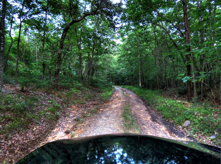 As the daylight faded, I searched high and low for any of the remaining foundations, chimneys, or other artifacts indicating that a town once stood here. Although I found a couple of small clearings, most of the views looked pretty much like this one.  In the end, I found no signs of this once-significant town whatsoever. But I’ll include Curtis Warwick’s beautiful photo of the twin chimneys that are still there, somewhere in the trees and bushes of Lignite. (You might enjoy his other photos as well; this fellow is a true photographer.) I’ll be back—in the winter, when the leaves are down—and find for myself what’s left of Lignite.  I drove back down the mountain, managing to dodge the larger rocks on the way, and headed in the general direction of Roanoke. In Oriskany, I spotted the eclectically designed 1903 King Memorial Community Church…  …and a little further on there was a Scenic Mailbox at Slippery Ford Road, plus an awesome, 240-foot-long swinging bridge over Craig Creek. I immediately began walking across the bridge to get a photo—and after less than a fourth of the way, I stopped dead in my tracks. That bridge was jouncing up and down by at least a foot, and it was also tilting violently side to side and threatening to pitch me over the low wire rail and into the creek! I’m not afraid of heights, but I will sheepishly admit that I turned around (very carefully) and gingerly walked back to terra firma. I’ve waded into rapids, climbed rock walls, ventured up and down goat trails by car, motorcycle, and on foot, and done any number of other foolish things in order to get a photo for you all, but I could not cross that dang bridge!    Continuing on, my iPhone eventually reconnected to civilization, and I called Santillane, a nearby stately mansion B&B, in hopes of getting a room for the night. They hadn’t gone to bed yet, but they did politely suggest that I book a room a couple of days in advance, rather than a few minutes…  Thankfully, the Holiday Inn Express in Troutville was happy to see me, and Cuccio’s Italian Restaurant was still open and cooked up an outstanding “turnover”—kind of like a folded-over pizza. And there was even a handy Shell station, since the trip computer had been getting more and more agitated since leaving Lignite. All’s well that ends well, and it had been a great first day of touring. Last edited by Rick F.; 08-20-2013 at 01:24 PM.. |
| 08-20-2013, 01:13 PM | #2 |
|
Lieutenant Colonel
946
Rep 1,910
Posts |
Day Two
Remember the troubles I’ve been having with my Garmin Zumo 550 GPS for the last couple of years? I finally bit the bullet and purchased a new, state-of-the-art Garmin Montana 600. During the prior day it had worked flawlessly, but when I clambered back into the Z4, it steadfastly refused to pick up a satellite signal (with or without the external antenna mounted). I had the Zumo as a backup, but it, too, refused to cooperate. After 45 minutes of trying to coax either one of these dimwits into life, I set off on my tour, furiously scrolling the maps by hand and missing every third turn.  It was relatively easy to find the Santillane mansion, where I had hoped to spend the prior night. The original Santillane was built in about 1795 by Colonel George Hancock and his wife Margaret. Their daughter Julia married William Clark at Santillane in 1808, shortly after Clark and Meriwether Lewis returned from their famous expedition to explore the Louisiana Purchase for President Thomas Jefferson. The present mansion was built in 1835 by Henry Winston Bowyer, using the kitchen wing from the earlier home. Santillane definitely qualifies as a place to come back to in the future (with at least 2 days’ notice, of course!)  The next goal was to find the historic Hawthorne Hall farmhouse. It was built in 1824 and still serves as the principal residence for a 179-acre farm. Without either GPS, it took some doing, but I finally found the place, only to discover that it’s almost entirely obscured behind a wall of trees. It was built by an elderly widower, Robert Harvey, for himself and his widowed daughter Mary Harvey Trigg. (Photo courtesy of the Virginia Department of Natural Resources.)  Fortunately, the hillside road back toward civilization offered some nice views.    Now that I’d relocated myself on the static Garmin map, it was easy to find the Breckinridge Mill. At 3½ stories, it’s one of the larger gristmills I’ve seen, particularly since it dates back to 1822. It continued in operation until 1939. 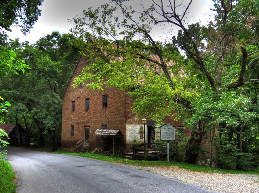 After retracing my steps back to Route 606, I parked the Z4 in an open space for a while in another vain effort to get the Montana 600 to locate a few of the nearly 20 GPS satellites that were circulating merrily on this relatively clear day. While I waited, I wandered over to get this photo of Catawba Creek, which I would be following for a considerable distance. In the meantime, the elderly Zumo woke up enough to identify the satellites, although the connection subsequently came and went until 12:45 PM, when the Montana finally got its act together. Dang technology!  Somewhere along the way, I spotted this colorful house behind some trees. It appears to have been abandoned, although relatively recently.  Despite my GPS problems, it was a glorious day. The positive effects of sun, wind, sky, and ever-winding roads were gradually improving my mood. And the best was yet to come in the form of five classic old resorts and spas.  The first one I encountered had been the Roanoke Red Sulfur Springs Resort, outside of Catawba, VA. It started in 1858 and soon became very popular with the genteel (and well-heeled) people who traveled from resort to resort in the summer months to “take the waters.” The Catawba sulphur and limestone spring water was especially prized for its medicinal properties. Other spas on the circuit included the white sulfur springs (now the Greenbriar Resort), the hot sulfur springs (now the Homestead Resort), the warm sulfur springs (now, and then for that mater, the Jefferson Baths), the Sweet Springs, and the Sweet Chalybeate Springs. The mineral waters in each were distinct, and entire books were written about how to maximize the health benefits from their mineral properties. There is almost nothing left of the old Roanoke Red Sulfur Springs at Catawba. These are the only images I could find of the resort, main hotel (which could hold 300 guests), and the gazebo covering the spring’s outlet. Only the last of these still exists, and in planning the trip I’d managed to spot it on Google Maps’ satellite view.    By the late 1800s and early 1900s, business at the mineral springs resorts was slowing—in significant part because many patrons believed, correctly, that consumption (tuberculosis) was spreading at the spas. As demand for mineral springs spas declined, demand for sanatoriums increased, and a number of the former were purchased by States and turned into the latter. Such was the transformation of the Roanoke Red Sulfur Springs into the first of Virginia’s three major tuberculosis sanatoriums, the Catawba Hospital, in 1908. Fresh air was considered the principal cure for consumption, and patients lived and slept in the open air in these “lean to” structures.   The old hotel became the hospital’s administration building (and later its nurses’ residence), and with a new infirmary building the hospital facilities rapidly expanded to treat up to 1,260 inpatient residents at a time.   The advent of thoracic surgery in the 1920s and the development of streptomycin in the late 1940s were finally effective in treating tuberculosis, and over time the sanatoriums were closed—or, in the case of the Catawba Hospital, converted to other uses. Where the Sanatorium’s main infirmary used to stand, today there is the modern Catawba Psychiatric Hospital.   The 1916 Brauer Chapel from the Sanatorium still stands…  …as does the original resort gazebo that shelters the sulfur spring fountain—except that this isn’t it! This one was in the right location, but the real one, with its iron structure, turns out to be a little further on and down a steep slope. I’ll find it the next time.   Leaving the site of the Roanoke Red Sulfur Spring Resort on Catawba Creek Road, I strayed onto an abandoned farm for a brief look. The only signs of life were a very large population of barn swallows, who were either (i) quite happy, or (ii) a bit irritated to see me. It’s a little hard to tell with birds.   The Homeplace Restaurant in Catawba is highly regarded, particularly by hikers along the Appalachian Trail, which runs close by. It started life as The Summit mansion, which dates from 1907. The current owners bought in the late 1970s after it had been vacant for some years, renovated it, and turned it in to the Homeplace.  How’s this for an attractive carport? I suppose that anyone brave enough to actually park a car on this contraption might also be willing to use it as a ramp for working on the car from below…   Eventually I reached New Castle, VA, which is the only incorporated town in Craig County. The county’s historical society is housed in the Old Brick Hotel, which was built around the town’s original, pre-1834 tavern and expanded in the 1850s. The notorious outlaw Jesse James is reputed to have been a guest.   The “new” Craig County Courthouse was completed in 1852, octagonal cupola and all. It was occupied by Union forces in 1864, and the interior staircase still shows signs of sabor slashes. It is now the oldest, unmodified courthouse in Virginia.  New Castle’s old homes range from this basic log cabin…  …to the 1889 Queen-Ann style house built by attorney James Marshall. This view is the back of the house, since the front was undergoing renovation.  Abe E. Humphreys was president of the New Castle Land & Improvement Company, which was formed to promote the expansion and development of the town. They had considerable success during 1900-1920, but the decline of the mining and timber industries, plus the Great Depression, led to a substantial decline in New Castle’s population. (It has remained largely unchanged at about 200 residents ever since). This was Abe’s home in 1890.  Did I mention what a pretty day it was? Or that many of the structures have bright red roofs? In the background is the New Castle United Methodist Church, which sits on land that Abe sold to the church’s trustees for $1.00.  “The Castle” is the most stately mansion in the town. It was built for local merchant and politician Nathaniel Spessard in 1898 at a cost of $7,500. 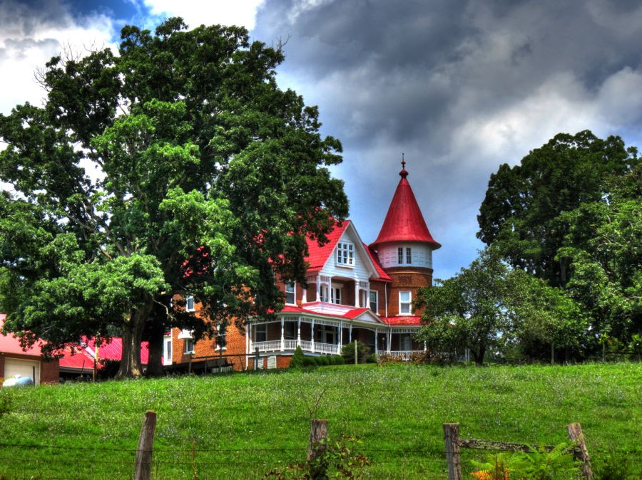 As I left New Castle and worked my way around the tight turns of Cumberland Gap Road, I found (i) a scenic view overlooking the town (with the red roof of The Castle just visible to the left)…  …(ii) several nifty old houses that looked abandoned, but probably weren’t, such as this one…  …and (iii) this 1883 Methodist church just past Looney, VA, complete with separate entrances for women and men.  I also encountered a lengthy traffic stop for road repaving. For a good 20 minutes, no traffic moved in either direction. Eventually, a county escort truck led us slowly along for a couple of miles, only to stop again while the paving machine was reloaded with asphalt, by another truck blocking our path. The efficiency of the operation left a bit to be desired.   Soon enough, however, I was past the construction and back in the midst of scenic history, such as the vacant 1912 New Bethel Christian Church. Only the barest trace of its original driveway was visible—but I used it anyway.  I loved the tidy and organized Long Oak Farm.  In contrast, the hamlets of Simmonsville and Huffman appear well on their way to ghost-town status.   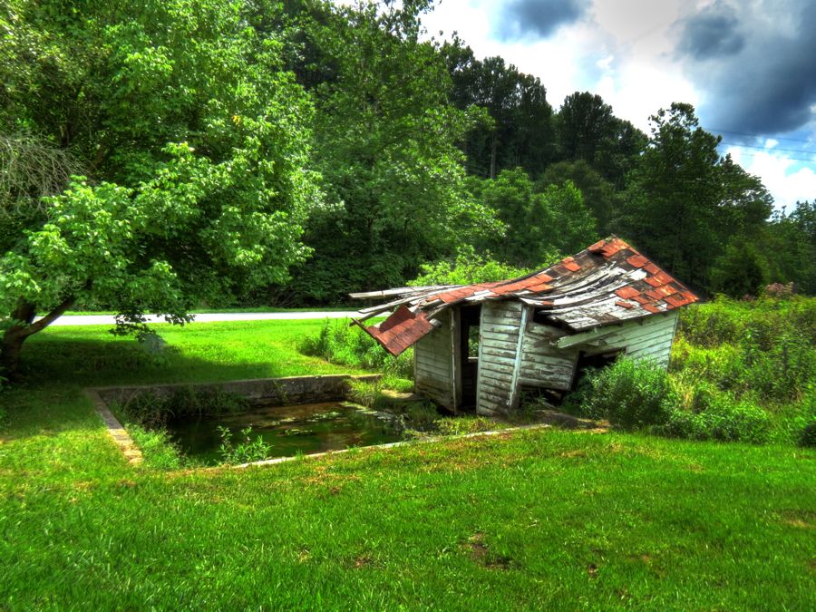 Most of you have seen or heard of the 1987 movie Dirty Dancing, starring the late Patrick Swayze and Jennifer Grey. It was set in the Catskills in 1963. I had read that much of the movie was actually filmed at the Mountain Lake Resort near Pembroke, VA, and I decided to see what was left of the old resort.   I managed to find Mountain Lake Road, and the always-willing Z4 tackled the steep uphill climb with relish, enjoying tight turn after tight turn. Around one of these, I encountered a large owl standing smack in the middle of the road! Surprisingly, it did not fly away as I braked to a complete stop only a few feet shy of the bird. When I reached for my camera, however, it took wing. It was about 2 feet tall, with very prominent white feathers encircling its large eyes. I’m pretty sure it was a barn owl, although these are less common in the mountains. Given the very rural nature of the road, and the lack of any apparent civilization, I began to wonder whether there would be anything left of the old resort. It had looked like this in the opening scenes from the movie:  To my surprise, it still looks exactly the same. Not only does it still exist, it’s in great shape, and almost all the rooms were filled, even in the middle of the week. (In retrospect, I had driven up the back way to the lodge; the front way is much more accessible.)  Here are a few more comparisons between the movie scenes and my own photos, 26 years later: The lodge’s dining room was largely unchanged…   …as was the cabin where Baby’s (Jennifer Grey’s) family stayed, although the steps have been relocated. Note, however, that Mountain Lake was very close to the cabin in 1987, but it is no longer nearby today. Did they move the cabin?   Nope—the lake is nearly empty! These pictures of the gazebo were taken from almost exactly the same vantage point. The lake used to lap right at the bottom of the stairs leading to the gazebo. Not any more.   This iconic nighttime scene of Johnny and Baby practicing their dance lift in the lake was filmed just off of the boat dock. Today, it’s a field of grasses and weeds. The natural lake is situated at the top of a mountain, nearly 4,000 feet above sea level, and fed by local springs and streams. It’s been here for roughly 6,000 years, gaining additional water from rain and snowmelt in wet years, and losing a constant flow through the soil and rocks forming the bottom of the lake. As a result, Mountain Lake goes through extended periods of being full or empty, all depending on the volume of precipitation.   This scene shows Baby looking forlorn and wistful on the porch of the cabin. On the day of my visit, I heard a well-played electric guitar and an accompanying djembe drum. Further investigation led me to Tristan and Nick, who have been coming here with their parents every summer for the last 13 years. Tristan is playing his dad’s vintage Gibson SG, while Nick handles the accompaniment; they’ll both be high school seniors this Fall. (For comparison, Baby was standing at the far end of the porch.)  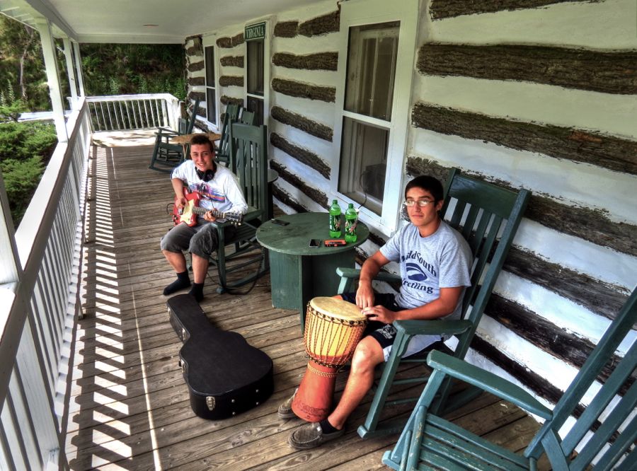 With some reluctance, I took my leave of the Mountain Lake Resort and pressed on toward further adventures. While retracing my steps back toward civilization, I stumbled across two different covered bridges across Sinking Creek that I’d failed to note on the way up. This was a bit remarkable, given that there are only eight covered bridges in all of Virginia. The first one shown below is the 1912 Link Farm bridge, which is on private property. The second one is the Sinking Creek Bridge, from 1916, which is on public land. Vive les ponts couverts!   Even better than discovering covered bridges is finding interesting old cars. The middle one is obviously a rare 1959 Chevrolet El Camino—the first year for this semi-pickup truck. But what are the first and third cars? I was especially taken with the third; although it’s clearly American, it has unusually handsome, European-like lines. Let the identification begin. (This means you, John!  ) )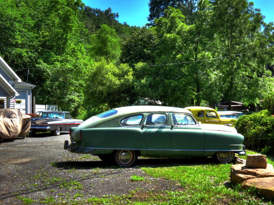 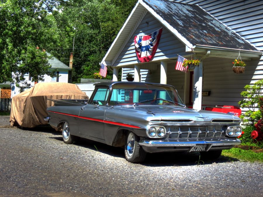  By now it was after 4:00 pm, and I still had three more resorts and many miles to go. I summarily decided that my 2-day trip would now be a 3-day trip. (It’s great to be retired.) As I motored in the general direction of the Craig Healing Springs, I encountered vacant-looking but active barns…  …together with the mother of all vacant houses. Although it’s barely noticeable from the roadside, this thing was mammoth. It’s built right into the hillside, which is probably all that’s keeping it from collapsing.   The first resort hotel at Craig Healing Springs was built in 1885, but business didn’t really take off until the early 1900s. There are more than 20 cottages, a spring-fed swimming pool, and a dance hall/ meeting pavilion here. In this photo, the 1909 building on the right is the dining hall, with the brick one on the left being the Oak Lodge, added in 1935. (Historical photos courtesy of the Jim Walker Collection at Virginia Tech.)   The 1885 Craig Hotel, now known as Old Central, is shown here on the right. The pool is just to the left of the kids. As business at other resorts was waning, the ease of reaching Craig Healing Springs by automobile made it very popular starting in the early 1920s. By the close of the 1950s, however, most vacationers were going to the beaches, and the resort’s time had come and gone. The Christian Church in Virginia bought the property and has used it as a retreat and summer camp ever since. The facilities have been maintained in their original condition throughout.   Route 658 in Virginia offered great views pretty much everywhere you looked.   Paint Bank, VA is said to have more buffalo than people—although I saw none of the former and precious few of the latter. I did talk with a nice couple who were out for a ride on their new Triumph Tiger 1200. And I briefly joined the “Girls’ Club” on the front porch of the Paint Bank General Store. (The local gossip was pretty much what you would expect from a town with more buffalo than people…)  The store featured an eclectic collection of foods and products, a swinging bridge that used to cross a stream (and now crosses from one part of the second floor to another, right over the tables in the Swinging Bridge Restaurant), and a t-shirt that reads “End of the World 9 miles, Paint Bank 12 miles.” (For the record, I made it across the restaurant’s swinging bridge.)  Behind the store, Tingler’s Mill is still in good repair after 150 years.  But Paint Bank was just the jumping off point for my pursuit of the final two mineral springs resorts. For that, I had to take Route 311 north to the Virginia-West Virginia border. Like every other road I’d been on throughout this trip, 311 proved to be a continuous series of curves, one right after the other. Great fun, even if you are trying to reach an actual destination on time!  Red Sweet Springs, later called Sweet Chalybeate Springs, dates back to 1836 and was a smallish resort that tended to handle the overflow from the nearby White Sulfur Springs and Old Sweet Springs. The waters were characterized as “the strongest carbonated mineral water in America and a certain cure for sterility.” In contrast to the Greenbriar and Homestead resorts, which had direct access by train, Red Sweet Springs required a challenging stage coach ride, and this resort never achieved the same popularity. By 1918, its doors were closed. The springs remain, however, and continue to pump out 600 gallons a minute.     From left to right in this 1974 photo (courtesy of the Library of Congress), we can see the north resort lodge, two cottages, and the south or “main” lodge—i.e., the one with the bar. The main lodge is no longer standing, but the larger northern one is still there, as are the cottages. “Bachelors’ Row” isn’t visible in the old photo, but it still exists. It was situated across Route 311 and on top of a hill due to the “sometimes rowdy good spirits of the bachelors.” The whole works is barely visible from Route 311, and one would never guess that this used to be a thriving resort area.   Just a mile down 311, and perched barely within what is now West Virginia, I found the glorious Old Sweet Springs resort. It started as a few log cabins in 1790 but soon became a massive facility and a major stop on the springs tour in the 1800s, rivaling the Greenbrier and Homestead in popularity. Its original developer, William Lewis, even built a four-county courthouse and jail on the edges of the property to promote settlement of the area. Six U.S. Presidents stayed at Sweet Springs, including George (and Martha) Washington and James (and Dolly) Madison. Other notable visitors included the Marquis de Lafayette, Henry Clay, Robert E. Lee, and Queen Victoria of England. Virtually unchanged from its original design, no other place in the country better reflects what resort life was like in the 1800s for “fashionable society.”   The extraordinary main hotel building was built in 1833. Its design is widely attributed to Thomas Jefferson, although later research suggests that one of Jefferson’s architectural colleagues actually drew up the plans. The “Grand Hotel” (or “Jefferson Building,” as you wish) is still in remarkably good condition. As best I can tell, it was the first hotel in the U.S. to use natural gas for lighting.    The resort’s ballroom still stands next to the hotel.  In a semi-circle off the end of the Jefferson Building were five brick cottages, referred to as “the Five Sisters.” Two have survived largely intact, but only the foundations remain for two others. As for the fifth “sister,” I suspect that it was converted into the ballroom sometime back in the day.   And what about the spring, that produces a steady flow of iron- and carbon dioxide-rich waters at exactly 73 degrees and that were said to “quicken the circulation, impart tonicity and vigor to the system, excite the animal passions, cheer the spirits, and inspire the mind with pleasureable sensations”? An elaborate bathhouse was built to house a fountain and pool fed by the spring. It featured towers at either end of the structure, providing separate entrances for men and women.    Unfortunately, both towers have collapsed within the last 10 years or so, but most of the rest of the bathhouse has survived. The pool could use a good cleaning, it seems, although the bright-colored algae, salamanders, and other flora and fauna added a festive appearance to the spring waters.     Sweet Springs closed during the Civil War and never fully regained its prior popularity. After the resort was finished off by the Great Depression and sat vacant for 12 years, the State of West Virginia purchased it in 1941 for the treatment of tuberculosis patients. The sanatorium was converted to a home for the elderly in 1945 and operated as such until closing in 1993. Remember the courthouse and jail from the late 1700s? Well, against all odds, the jail is still there. It is believed to be the oldest jail west of the Allegheny Mountains.  As a postscript to the Old Sweet Springs story, Warren Smith—a prominent Fredericksburg businessman and member of the National Trust for Historic Preservation—purchased the property in 2004 with the intent to renovate it, rebuild the 1800s golf course, and return the resort to its former glory. To raise funds for the project, he began marketing the spring water as “Sweet Sommer” bottled water and entered—and won—several international water-tasting competitions. By 2009, however, his business ran afoul of the FDA—and you don’t want to know the details… Following his death in November 2010, the water business closed down, and the resort has sat untouched. But if Bedford Springs can do it (see Sometimes They Come Back to Life), maybe there’s still hope for this once-magnificent resort. After hiking around Sweet Springs for quite a while (and possibly climbing through a fence or two), it was time to press on. I completed my planned tour, arriving back in Covington well after dark and enjoying a hearty, vending-machine dinner. Tomorrow would be time to head for home—but with a couple off-the-beaten-path detours, of course! |
|
Appreciate
0
|
| 08-20-2013, 01:15 PM | #3 |
|
Lieutenant Colonel
946
Rep 1,910
Posts |
Day Three
The next morning, I was pleased to find (i) another excellent Holiday Inn Express breakfast and (ii) that the Montana 600 snagged 8 or 10 satellites almost immediately. I set off to locate Iron Gate, VA and the headwaters of the famous James River. This involved guiding the remarkably patient Z4 down the steep and rocky Head of the James Road, whereupon I was solidly on Private Property. Fortunately, I located the ownera nice old fellow (who was, uh, about my age)and had an enjoyable talk with him. He told me a lot about the area and invited me to follow one of his tractor paths down to the river. There I found the Cowpasture River (on the left in this photo) and the Jackson River (on the right), where they come together to form the James.  The James River then proceeds downstream for 348 miles, on its way to the Chesapeake Bay and the first English colony in America, namely the Jamestown settlement of 1607.  Over the years, the Cowpasture and Jackson Rivers have washed quite a collection of stones to their confluence. I managed to find a couple of (probable) Indian artifacts without even trying.  Back in Iron Gate, I found other artifacts, in the form of this old home  and the vacant Iron Gate School. The town is apparently quite serious about keeping tramps, vandals, and roving photographers out of the school: Note that the windows have all been filled in with cement blocks! Note, too, that the little window in the top gable seems to have been pushed out slightly from the insideperhaps by some poor soul who got cemented inside the school and, with her last ounce of strength, was trying to escape?   Okay, an active imagination is not really a prerequisite for BMW touring; but it doesnt hurt! Back on the road, I set my sights for Interstate 81 and home, enjoying the heavy-duty clouds along the way.  When I got to I-81, however, I turned south instead of north. After all, if youre this close to the Natural Bridge, and if you havent seen it since you were 14, then you should probably make a side trip there. I was a little surprised to find that Route 11 still passes right across the bridge. Youd think that decades of car and truck traffic might jeopardize the integrity of this majestic rock formation, but apparently it hasnt. The Natural Bridge looked identical to my memories. More than 500 million years ago, it was part of a large limestone cavern, carved by Cedar Creek. Over time, the other parts of the cavern eroded and collapsed, leaving a 215-foot-high section of the tunnel roof. A young George Washington surveyed this area in about 1750 and engraved his initials in two places. In 1774, Thomas Jefferson bought 157 acres of property from King George III, including Natural Bridge, for 20 shillingsequivalent today to about $160! (And you thought only the Native Americans were cheated in various land deals ) Remember Frederic Edwin Church, the painter mentioned in my report Almost Heaven: The Hudson River Valley? Heres his 1852 painting of Natural Bridge, along with my modern photo.  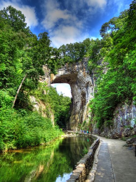 The Natural Bridge visitors center now has an indoor butterfly garden. Its important to watch where you step, since the little buggers are everywhere. I believe these are owl butterflies. They were happily feeding when I arrived, but they agreed to pose for an HDR photo.  Back on I-81 and heading north, finally, I soon approached Winchester, VA. It occurred to me that I could stop by the Museum of the Shenandoah Valley for a quick tour. (As documented in Before There Were Interstates, it was just closing when I tried to visit before.) The museums exhibits were great, and I especially enjoyed the fantastic model houses created by R. Lee Taylor. As indicated in these iPhone photos, its pretty hard to distinguish his scale-model rooms from the real thing.   The Glen Burnie mansion is still closed for renovations, but its historic gardens were open, statues and all.   As I drove by Charles Town, WV towards Harpers Ferry, I remembered that I had one more piece of unfinished business. Detouring onto Millville Road near Harpers Ferry, I found a largely unknown section of the Harpers Ferry National Historic Park and set off on foot to the top of this ridge. Why bother on such a hot day?  Because Id spotted the ruins of Jacob Allstadts original farmhouse, naturally! Readers with unusually good memories will recall that Jacob, his son John, and their seven slaves were taken hostage by John Browns raiders and held captive at the firehouse at Harpers Ferry. Fortunately, all of them survived the subsequent attack by Federal forces led by Thomas Jackson. Three years later, and then known as Stonewall, Jackson was back, this time to capture the Union armory at Harpers Ferry. He set up a substantial artillery force along Schoolhouse Ridge, which, together with artillery at Maryland Heights and Loundon Heights, poured fire onto the Union troops and led to the relatively quick surrender of 12,000 soldiers. Anyway, Jacob Allstadts farmhouse was situated on South Schoolhouse Ridge, and Id read that its ruins were still there. Sure enough  Although the house has deteriorated significantly even since this Library of Congress photo in 2009, recent efforts have stabilized the ruins.    With one last look at my longsuffering BMW, it was time to press on for home.  All told, my trip encompassed a little over 900 miles, including getting to the Roanoke area and back. It was a wonderful opportunity to explore what used to be, examine some of the most twistacious drivers roads Ive ever encountered, and to exercise an outstanding sports car. What more could I ask for? Rick F. |
|
Appreciate
0
|
| 08-20-2013, 05:57 PM | #5 |
|
Major
 78
Rep 1,443
Posts |
Rick, you never cease to amaze me or to outdo yourself. This tour and your account of it is by far my favorite, probably because it ventures even closer to my old regular stomping grounds.
I lived in Lexington from about 1987 to 1989 while my dad taught American History at a military institute that shall remain nameless. It was his first teaching job after he earned his Doctorate at W&M. Despite having been very young then and not spending much time there since I recognize the sites. I also haven't seen Natural Bridge since about that same time and it was a welcome site. A distant cousin of mine is (was?) the president of the investment company (I think?) that owns (owned?) it. My family history has gotten a little rusty lately. I need to brush up a bit. Edit: Found this. Angelo Puglisi is my distant cousin. I was unaware of the recent news. http://www.huffingtonpost.com/2013/0...n_3332505.html You picked some absolutely beautiful roads for this trip and it makes me miss the east coast even more but, yes, VA southwest of the area you visited does very much resemble WV. I spent most of my formative years in Bristol and I can say there's not much going on SW of Roanoke. Thanks, Rick!
__________________
 Last edited by itdnwiwbp; 08-21-2013 at 07:01 PM.. |
|
Appreciate
0
|
| 08-20-2013, 06:53 PM | #6 |
|
Major

151
Rep 1,134
Posts
Drives: '07 M Roadster
Join Date: Dec 2011
Location: Warner Robins, GA
|
Another great write up! Good job!
__________________
|
|
Appreciate
0
|
| 08-20-2013, 08:08 PM | #7 |
|
Captain
 
37
Rep 711
Posts |
Amazing as always. These posts are so good. You should really start your own website. You could link here when you have updates.
It would give you more freedom to really format it how you like. I would visit it often so I could live vicariously through your road trips. 
__________________
 |Evolve Airbox - Euro Headers - Strömung Exhaust - H&R Coils - 19" BBS CH-R| |
|
Appreciate
0
|
| 08-21-2013, 02:31 PM | #8 |
|
Iron Ring

11
Rep 316
Posts |
Glad you turned back on that fabled bridge!
Plan to investigate your source too... http://www.roadrunner.travel/magazin...-2013/page/40/ Wonderful tale. Thanks! Just finished reading Day3. I really enjoyed every image, and thoughtful descriptions. You make it so easy to read! Thank you Edit again.... a tease... Best Bike Roads in Ontario http://bikeroads.atspace.com/ Bikerlad has a great site. I am a has-been biker. However our Roadsters enjoy these roads too. And being short, I fit better in a roadster than trying to straddle a too-tall bike!
__________________
DaveL///Toronto. http://www.ironring.ca/
My wife's cars: Had a few... I'm the Navigator, capable of getting us lost at any time! Drives are longer! Last edited by DaveL--2mnycars; 08-21-2013 at 08:54 PM.. |
|
Appreciate
0
|
| 08-22-2013, 08:35 AM | #9 |
|
Lieutenant
9
Rep 452
Posts |
You are really enriching our lives, Rick. Thank you once again. The work and patience involved must be mind-boggling in that you can capture the photos within just a few days. Especially liked the Dirty Dancing reference points.
Oh, by the way, the third car in the photos is a Kaiser-Frazer. The model is most likely a Deluxe, the upscale versions would have been either a Manhattan or Dragon and would be a little fancier. Not to be confused with the Kaiser Virginian, which preceded the merged company!
__________________
Vibra Technics engine mounts / Rogue trans mounts / Stoptech brakes / original owner
Last edited by Walkurie; 08-22-2013 at 08:42 AM.. |
|
Appreciate
0
|
| 08-27-2013, 08:41 AM | #10 |
|
Lieutenant Colonel
11304
Rep 1,784
Posts
Drives: E86 3.0si
Join Date: Oct 2011
Location: Susquehanna Valley
iTrader: (0)
Garage List '55 Ford F100 [0.00]
'08 Z4 3.0SI [8.50] '66 Triumph TR4A [0.00] '85 Corvette [0.00] '64 Corvette [0.00] '68 Triumph GT6 [0.00] '19 VW Golf "R ... [0.00] |
Finally found the time to go through your post. How enjoyable - Plus how timely because this is the general direction/area we'll be vacationing in this fall. Great photography and captions.
That first vehicle is the 1951 Nash Ambassador (those taillights were only that year). |
|
Appreciate
0
|
| 08-27-2013, 01:49 PM | #11 | |
|
Lieutenant Colonel
946
Rep 1,910
Posts |
Quote:
Thanks--hope you have a chance to get through the whole works! Rick |
|
|
Appreciate
0
|
| 08-27-2013, 01:59 PM | #12 | |
|
Lieutenant Colonel
946
Rep 1,910
Posts |
Quote:
Glad you enjoyed the (extended) write-up. That's really interesting about Angelo Puglisi being your distant cousin. He seems to have created quite an enterprise at Natural Bridge--I mean, not just the bridge itself, but also the Natural Bridge Caverns, Natural Bridge Zoo, NB Wax Museum, NB Toy Museum, and maybe a few others I've forgotten. Actually, I don't know how many of these are actually owned by or associated with Natural Bridge itself--but collectively they kind of boggle the mind. As you note, the roads throughout this area were terrific. They were all twisty, up and downhill, and entertaining, and most were well-paved and free of gravel or other unpleasant surprises. The majority also offered good visibility, making it possible to "exercise" the Z4 pretty well while still within reasonable safety guidelines. I hope the State of Virginia will step up and buy Natural Bridge from your cousin and turn it into a state park. One way or the other, however, I'm confident that people will still be touring the place for at least another 300 years! Rick |
|
|
Appreciate
0
|
| 08-27-2013, 02:02 PM | #14 | |
|
Lieutenant Colonel
946
Rep 1,910
Posts |
Quote:
My nephew Matt made the same suggestion when he helped me set up a new site to get additional online storage for all these photos I seem to keep taking. I do like the idea of a unique website with access to all the trip reports, plus other information that might be of interest. I've added the project to my list! Rick |
|
|
Appreciate
0
|
| 08-27-2013, 02:20 PM | #15 | |
|
Lieutenant Colonel
946
Rep 1,910
Posts |
Quote:
Thanks! I was very surprised at just how jouncy that swinging bridge was. I've been on other ones, and they weren't nearly as daunting. A key issue, I think, was how wide the boards were. In retrospect, I should have walked on the bridge the same way that you move around in a canoe--namely, by keeping all your weight in the very center. By stepping along each side of the bridge, I managed to inadvertently get it rocking back and forth. A lot! For comparison, check this photo of my brother Curt and his wife Kathy at last weekend's ziplining adventure. See how narrow the bridge is at the bottom? (Not to mention how relatively high the handguides are.) I'm sure I could have handled this bridge just fine. Yes, I'm very confident Well, maybe Ah, who am I trying to kid--it still looks terrifying!  Speaking of motorcycling, when I had my BMW F650CS, a neighbor down the street had an R1200GS--a very tall bike if there ever was one. I noticed her riding up to the BMW club corral at Summit Point Raceway, and I was puzzled why she made several very tight circles in the grass before finally stopping. Turns out it was to make sure there was a place where she could reach the ground! (She's 5'3" tall.) We swapped bikes for the ride back to Catonsville, and that's what convinced me to buy an R1200GS. Of course, I put the optional tall seat onto mine! I'm not sure when I might get up to Ontario, but it's good to know that there are a lot of great roads up there. Rick |
|
|
Appreciate
0
|
| 08-27-2013, 02:46 PM | #16 | |
|
Lieutenant Colonel
946
Rep 1,910
Posts |
Quote:
"Enriching your lives," eh? Well, it's the least I can do for this pack of reprobates! ") Believe it or not, I took the photos at the Mountain Lake Resort without having seen Dirty Dancing for a very long time. I got lucky in that I used a number of the same vantage spots that were used in the film. I was able to just grab a few screenshots from the movie that aligned well with my photos. (It would have been smarter to do it the other way around, no doubt.) As for the Kaiser-Frazer, well done! It's such a little-known car that I wasn't sure anyone would be able to identify it. (I cheated by checking the rear license plate holder, which clearly said Kaiser. I would have had a lot of trouble, otherwise.) Prior to seeing this car, I wasn't aware that Kaiser cars were related to Henry J. cars, or that they were produced by the industrialist Henry J. Kaiser. Of course, he also founded the Kaiser Shipyard, Kaiser Aluminum, Kaiser Steel, the mammoth Kaiser Permanente health system in California and other parts of the U.S., the Kaiser Family Foundation, and other ventures and organizations over the course of his lifetime. Unfortunately, he only made cars for a few years. I agree on your identification of the specific model as being a Deluxe, although, in retrospect, I should have checked the interior for the "Dragon" upholstery. FWIW, the company brought back the Virginian name for a low-cost version of this same car for 1 year, I believe. Regardless, I thought it was a great-looking car, particularly from the rear three-quarter view. Here's a photo of Henry J., at the wheel of his far-ahead-of-its-time 1946 articulated bussupercharged diesel engine (just like all modern Greyhound buses), alloy coachwork, air conditioning, and all. Rick 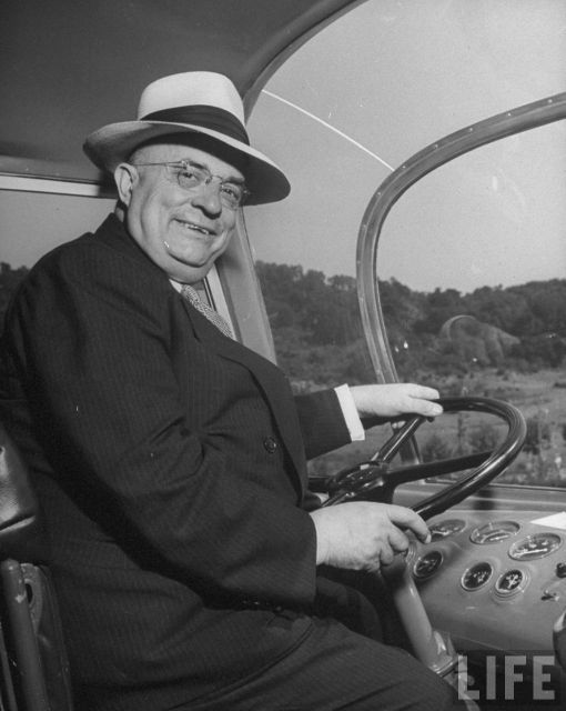 |
|
|
Appreciate
0
|
| 08-27-2013, 04:14 PM | #17 | |
|
Lieutenant Colonel
946
Rep 1,910
Posts |
Quote:
And well done for you, too, sir! It look me some work to identify the car as a Nash, since there weren't any trim pieces on the car (although, in retrospect, the hubcaps say Nash on them). If you're inclined to visit the Old Sweet Springs resort on your vacation, see if you can get a photo of a mystery building that I overlooked. It appears to be the ruin of a building, judging by the shadows in this Google Maps satellite shot:  I'd love to find out what it actually is! Rick |
|
|
Appreciate
0
|
| 08-28-2013, 08:20 PM | #18 |
|
Iron Ring
11
Rep 316
Posts |
Rick, great story about the BMW bikes! Years ago my friend had an R69S with a sidecar. One and only ride in a sidecar! Fell in love with the bike.
I'm afraid of heights. You wouldn't catch me on that bridge! Sorry! (fell off a 10 wall when I was 4 or so. )
__________________
DaveL///Toronto. http://www.ironring.ca/
My wife's cars: Had a few... I'm the Navigator, capable of getting us lost at any time! Drives are longer! |
|
Appreciate
0
|
Post Reply |
| Bookmarks |
| Thread Tools | Search this Thread |
|
|