What could be better than a BMW ride or drive through the twisting mountain roads of West Virginia in the Springtime? Add in some pursuit of Civil War and other historic sites, and the decision was easy.
On April 3rd I set off on this journey, using a route from
RoadRunner magazine (see
West Virginia Civil War Tour). It promised to be a fun, if ambitious, trip: the author had spent almost 5 days on the road, while I would be attempting it in just 2 days. My starting point was Harpers Ferry, WV, which I've visited periodically since I was 7 years old. This somewhat dizzying aerial photo shows the Potomac River on the left merging with the Shenandoah River on the right, with the town nestled on the point of land in-between the two rivers. That's Maryland in the upper left, West Virginia to the right and below, and a tiny bit of Virginia at the upper right. (Unless noted otherwise, all historical photos are from the Library of Congress.)

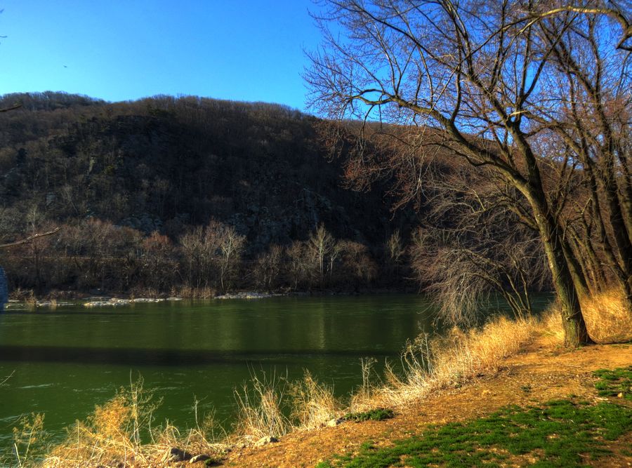
Although Spring had officially been in effect for a week and a half, I saw few signs of it. This is the Shenandoah, looking rather more green than usual.
Over the years, a number of bridges have been built across the rivers into Harpers Ferry—and a number of them have been burned, blown up, or washed away by floods. The support piers remain, however, and in some cases are now home to small trees that somehow manage to grow right out of the stones. (For extra credit, see if you can find these ruins in the aerial photo above.)

Robert Harper arrived here in 1750 and started a ferry in 1761. George Washington visited in 1785 and later recommended the creation of a U.S. armory at this site. The subsequent Harpers Ferry Armory and Arsenal produced roughly half of all the rifles and pistols for the U.S. Army. The huge stockpile of weapons in the arsenal led abolitionist John Brown to capture Harpers Ferry in an effort to start (and arm) a massive uprising of slaves in October 1859. U.S. Marines, led by a Col. Robert E. Lee and his assistant Lt. J.E.B. Stuart, swiftly put an end to Brown's attack. In this period illustration, John Brown and his raiders, together with several hostages, have retreated to the arsenal firehouse and are fighting with a local militia prior to the marines' arrival. (The firehouse, later known as "John Brown's Fort," is pictured here on the right.)

John Brown was captured, found guilty of treason, and hanged in nearby Charles Town in December 1859. But his raid stunned the nation and helped propel it into the Civil War 18 months later. The Harpers Ferry arms factory and arsenal immediately became a strategically important objective for both the North and the South. Only 6 days after the Confederates fired on Fort Sumter, a militia attacked the small Union force at Harpers Ferry and drove them across the Potomac River into Maryland—but not before the defenders had set fire to the arsenal and armory buildings, to prevent them from falling into Confederate hands. Much of the arms-making equipment, however, was salvaged by the southern forces and relocated to Richmond. In this historical photo, Union troops are camped near the arsenal, with the firehouse shown in the center. (Note also the two churches in the upper part of the scene, to which we will return.)

In 1891, the firehouse was disassembled and set back up at the Chicago's World Fair. In 1895, a farmer near Harpers Ferry bought it and assembled it on his property. Next, Storer College in Harpers Ferry acquired the firehouse and added it to their hilltop campus overlooking the town in 1909. (That's where it was when my parents, brother, and I first visited in about 1957.) Then in 1968, the National Park Service moved the firehouse back to the lower part of town, near its original location. On the day of my visit, it was standing proudly in the sunshine and was open to the public promptly at 8:00 AM.


The National Park Service lists memorable Harpers Ferry floods in 1748, 1753, 1852, 1877, 1889, 1896, 1924, 1936, 1942, 1975, 1986, and, for good measure,
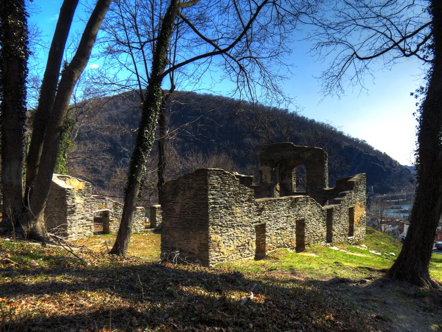
twice in 1996. "Memorable" appears to involve water levels of at least 29 feet above normal. Such inundations are not surprising, given that much of the town is situated on low ground in-between two major rivers. As a result of these floods, plus the Civil War (when Harpers Ferry changed hands a total of 8 times) and the Great Depression, the lower part of town was virtually deserted by the late 1950s and early 1960s. Almost all of the buildings were in poor condition, with doors and windows boarded up, crumbling foundations, missing roofs, etc. My brother and I naturally discovered a back way into several of them and were able to roam about the interiors and have a great time exploring.
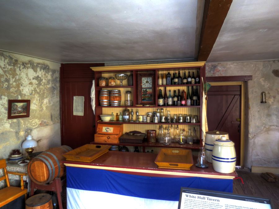
Since then, the National Park Service has razed many of the unstable ruins and restored most of the other buildings to their configuration at the time of the Civil War. It's now a much better place to visit, if a little less amenable to reckless exploration! This is the interior of the White Hall Tavern. It was owned by German immigrant Frederick Roeder, an ardent supporter of President Lincoln. Sadly, while hoping to spot the U.S. flag flying on the Maryland shore, Mr. Roeder was killed by an errant shot from a Union soldier and became the town's first civilian casualty of the war.
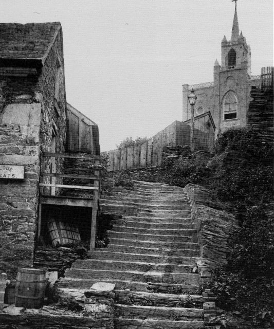
These steps were carved directly into the 500-million-year-old phyllite stone of the hillside and have become well-worn over the years. The Appalachian Trail follows these steps (and the walkway above) right through town. St. Peter's Catholic Church was built in 1833 and was substantially remodeled in 1896. St. Peter's flew a British flag throughout the Civil War as a sign of neutrality, and it was the
only church in Harpers Ferry that wasn't destroyed by Union or Confederate shelling. It continues to hold services to this day.

For all the times that I'd walked by St. Peter's on the way to Jefferson's Rock, I'd never once been inside. On this day, a friendly workman invited me to climb up to the balcony for a photo.

Speaking of Thomas Jefferson, he passed through Harpers Ferry in 1783 and paused to admire the view from this large stone outcropping that is now named after him. He later wrote "This scene is worth a voyage across the Atlantic."

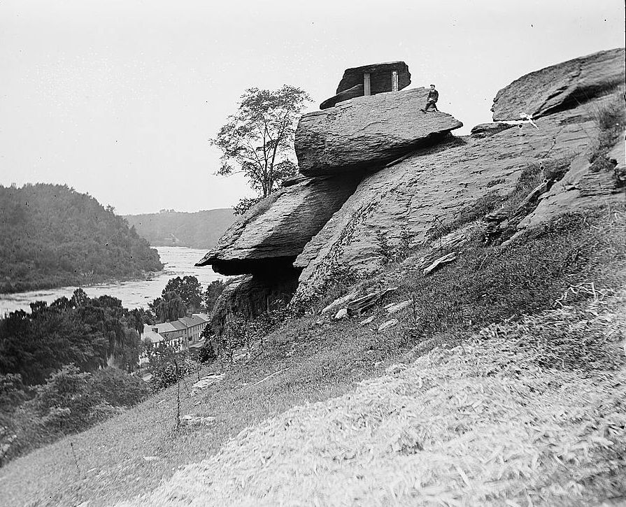
These days, climbing on Jefferson's Rock is strictly prohibited, and many Warnings of Grave Danger are posted. Back in the day, everyone climbed up onto the rock, including these, uh, dapper folks. The pedestals were placed under the top-most rock in about 1855 to help prevent it from crashing down onto the buildings below. (The rock remains in place, but the buildings are long gone.)

Oh, and here's a picture of Yr Fthfl Srvnt and his cousin Susan leaning on the rock in 1968, before all them warnin' signs went up.

And what about the other church seen previously? In this historical photo from early in the war, St. John's Episcopal Church has suffered minor damage—but much worse was to come. Only a portion of the stone walls still remain.

Robert Harper had this large house built for himself. It was finished in 1782—slightly after Mr. Harper's death. His niece Sarah and her descendants lived here for many years, and the mansion was later used as a tavern and residence for armory workers until falling into ruin. As shown in the old photo, there used to be a walkway connecting the upper porch with the higher ground to the left.


Harper House was extensively restored in the late 1960s and early 1970s, following a protracted battle between the National Park Service and the indomitable ladies of the Shenandoah-Potomac Garden Club. (No, I'm not making that up…) The house isn't open to the public, but, if it were, the inside would look exactly like this photo—without the "self portrait" of a tall, gawky photographer in the mirror.

This railroad station has served Harpers Ferry since 1889 and was built on the foundations of the armory. These days, many people commute to Washington, DC from this station.


From the station, the railroad tracks lead across the Potomac and through a short tunnel beneath Maryland Heights.

Remember that part about " reckless exploration"? Yes, my brother Curt and I used to routinely walk through this tunnel. Much worse, we discovered that there were iron rungs on the southern wall of the tunnel opening (on the right, in this old photo). A foolish-but-enterprising kid could climb these rungs to the top of the of the tunnel's support structure. And if you look carefully, you'll see that near the top (which was a good 45 feet above the rocky ground) the structure juts out significantly. To get to the next rung, you had to reach up and
behind you as you climbed. Going down was even worse… Once on top of the tunnel entrance, incidentally, you were greeting by a completely uninteresting pile of gravel—which was not a sufficient disappointment to keep you from climbing up there again on your next visit.
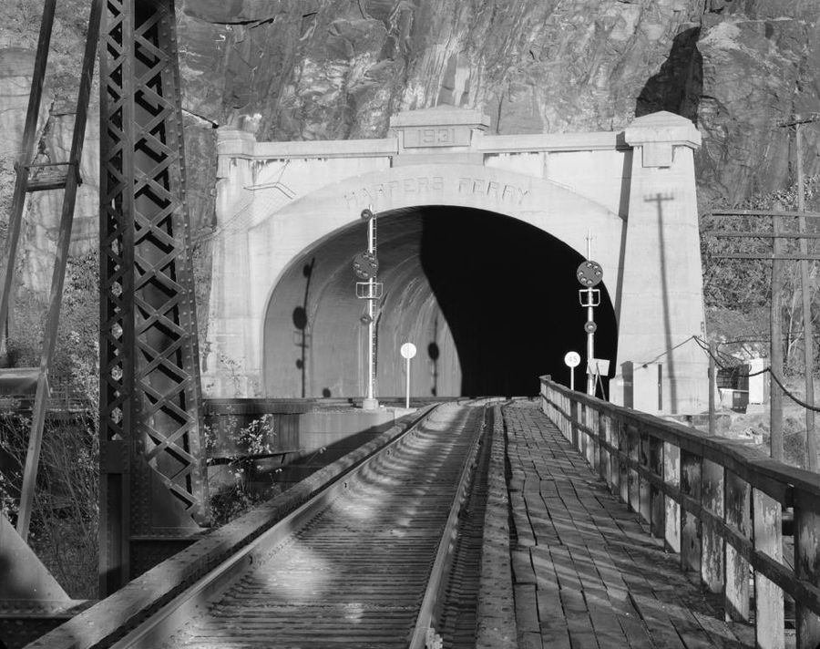
Honest, it's a wonder that any of us survive into adulthood. The last time I was there, I was relieved to see that the iron rungs have been removed.
In September 1862, in preparation for his invasion of Maryland, Gen. Robert E. Lee was worried about the large Union force stationed in Harpers Ferry. Concerned that they might be brought in behind his forces or used to stop his return, he ordered an attack on the town, led by Generals Stonewall Jackson, McLaws, Walker, and Hill. Their troops bombarded Harpers Ferry from Maryland Heights and Loudoun Heights, and attacked on land from the west and south, which, surprisingly, were undefended. These actions prompted the surrender of the Union forces and the capture of more than 12,700 soldiers, 13,000 rifles and pistols, and 47 cannon. Gen. A.P. Hill's troops stayed to hold Harpers Ferry, while the others marched to Sharpsburg, MD, where the Battle of Antietam began and soon proved to be the single bloodiest day of the Civil War. The bulk of A.P. Hill's men arrived late in the battle, just in time to turn what would have become a wholesale Union victory into a stalemate. A stalemate that involved a total of 22,717 dead, wounded, or missing Union and Confederate soldiers in one day.

Leaving the Harpers Ferry, I stopped for a quick photo of the ruins of the Shenandoah Mill, which produced wood pulp for making paper. The five huge sluiceways fed a total of ten turbines, which powered the various rollers and grinders. The mill operated from 1888 to 1935. Remember the "memorable floods"? The one in 1936 destroyed the mill once and for all.


Shepherdstown, WV is also home to several former bridges. Imagine this scene on October 18, 1862—the day after Antietam—with Union artillery on the Maryland shore (to the right) and Confederate troops on the opposite shore blasting the daylights out of each other. The Battle of Shepherdstown allowed Robert E. Lee's army to escape safely back into Virginia following Antietam. Union Gen. George S. McClellan's timidity in pursuing the Confederates, and the resulting standoff at Shepherdstown, infuriated President Lincoln and led directly to McClellan's dismissal as leader of the Union Army soon thereafter.

Shepherdstown still has a couple of active bridges over the Potomac. While I wasn't frightened of walking through the Harpers Ferry railroad tunnel as a kid, I definitely drew the line at walking out onto this single-track bridge to get a nice photo of the river!

In hunting for Thomas Shepherd's historic 1739 grist mill, I mistakenly found this tobacco warehouse, which dates back to 1788. At least it was reasonably scenic in its own right. But now I gotta go back…

Descendants of Thomas Shepherd continue to live in Shepherdstown. The historic 1773 Bellevue mansion sits about 400 feet above the Potomac River and is currently home to one branch of the family. It started out as a single-story stone building, and it has been added to extensively over the years. Originally built by Joseph Van Swearingen, an officer during the Revolutionary War, the mansion has hosted Thomas Lord Fairfax, George Washington, Henry Clay, and William Jennings Bryan among other notables.

Before long, I found myself in Hardscrabble, West Virginia, now known as just Scrabble. In addition to several other historic buildings, I was taken by the 1882 single-room schoolhouse. Danged if it didn't look right out of a prior Pennsylvania trip (see
The Mystery of the One-Room Schoolhouse. Someone must have sold these things as kits… Like the others I've seen, this one has been converted to a residence.

When I arrived on the outskirts of Martinsburg, WV, I managed to find Patterson's Mill on the first try (and without confusing it with a tobacco warehouse). The miller's original log house was nearby (now covered with weatherboards). With the temperature reaching 40 degrees, the faithful BMW Z4 once again became a roadster.


The mill is part of the "Tuscarora Historical Area," as recognized by the National Registry of Historic Places. So too is this little one-room schoolhouse that, for once, is not just like all the brick ones.

The Tuscarora Presbyterian Church was built in 1745, and its first minister, the Rev. Hugh Vance, is buried in the cemetery. The simple beauty of the original building is rather overwhelmed by front and rear additions from the 1960s. As luck would have it, a local member of the church invited me to tour the interior, where I found this beautiful and quite rare hand-tinted ambrotype photograph of the original church in about 1855. ("
Ambrotype" photographs were made using collodion and silver nitrate on a piece of glass.) There are still pegs on the interior walls where the earliest members would hang their rifles—for quick access in the event of Indian attacks. Thanks, Becky, for the tour and information!


The Tuscarora Poorhouse started as a small log building in 1788, on land that was once owned by a certain David Crockett. The residents worked on a surrounding farm to help feed themselves and support their care. The poorhouse continued in operation until 1950, and it is now in the center of the Berkeley County Poor House Farm Park, which features sports facilities, pavilions, various activities, and a small trout-filled lake.

Oddly enough, the front door to the poorhouse was not locked, and I managed to take a quick tour of the interior. It was only a little spooky, and it looked like efforts were underway to renovate the place.

Bella Vista has been sitting proudly on top of a hill in the historic district since 1807. Frederick Seibert lived here and operated a distillery and tavern on the property.


The Tuscarora district has more historic homes per square mile than you can keep track of.

Not to mention the occasional scenic BMW…

In downtown Martinsburg, I was disappointed to find—again—that the Belle Boyd house and museum was not open. (I was 12 days too soon.) Belle Boyd was an enterprising spy for the Confederates during the Civil War, and she will feature in one of my reports some day.

Martinsburg was founded by General Adam Stephen, a Scottish immigrant who led a
distinguished if sometimes checkered career as a doctor and military officer. I'd been to his 1772 home previously—but at that time I hadn't realized that the eastern part of Martinsburg is riddled with underground caves and passageways. Most of them have been filled in for safety, but a few still exist, including one that leads directly into Gen. Stephen's house. It was only recently discovered. (Tunnel photo courtesy of the
General Adam Stephen Memorial Association.)


Did I mention the plethora of stately homes? This is the 1856 Elias Pitzer house, west of Martinsburg…

…while this is "Ar-Qua Springs," once the home of Thomas Thornbrough and believed to have been used as an early meeting house for Quakers. The stone portion, closest to the camera, was built in 1752, with the adjoining log structure added soon thereafter. To the right is a stone springhouse. Try as I might, I could not learn where the name "Ar-Qua Springs" came from.

From 1897 to 1939, local African American children were taught in the one-room Mt. Pleasant School. After the school closed, it became the Mt. Olive Methodist Church and has held occasional services ever since.

My next stop was to visit my friends the Polimeni family in Capon Bridge, WV. The Polimenis are an interesting clan. Patriarch Ron used to race cars in the 1960s at such venues as Sebring, Lime Rock, and Bridgehampton. He and his wife Dotti are both artists. Their son Nick works in Connecticut preparing historic racing cars for vintage racing. Daughter Lydia is a photographer in Washington, DC. Son Alex is also an artist and racing enthusiast who, at 21, is a veteran corner worker for the SCCA, BMWCCA, and PCA at Summit Point, WV. Here's a photo of Alex driving my Z4 in 2009.

I was visiting the family in part to see how Alex was doing following a severe car accident. He had volunteered to ride along with the director of a camp to pick up a late-arriving camper at the airport. Since it was late at night, Alex was concerned about the older man making the long round trip on his own. On the way back, the van left the road, hit a bridge abutment, and rolled over violently. Although the driver and camper were largely okay, Alex lost all four fingers on his right hand. For a young, right-handed artist with no health insurance, this result was catastrophic.
The good news is that Alex has a very positive attitude and refuses to let his injury get him down. He has worked tirelessly to adapt to his new circumstances, and he is continuing to work as a videographer and corner worker. His doctors have determined that he is an excellent candidate for a prosthetic hand. They are expensive, however, and neither he nor his family can afford the cost. Pennie Saum, a heroic nurse who stopped at the scene of the accident to assist, has established a voluntary fund to help finance the prosthetic. The fundraiser ends in only 2 months, however, and there is quite a ways to go to meet the goal. If you would like to help, please see
A Hand For Alex. A contribution of any size would be put to good use and help facilitate this terrific young man's ability to use his abundant natural skills.
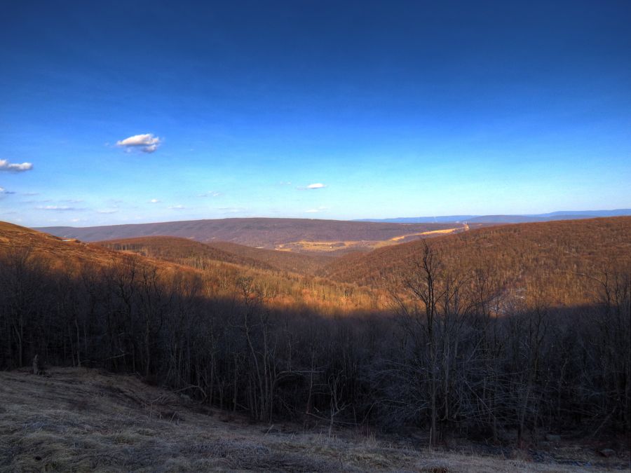
After visiting with the Polimeni family, I pressed on toward my overnight destination at the Canaan Valley State Park. The farther I went, the higher the elevation became, and I began to notice lengthening shadows and patches of snow here and there.

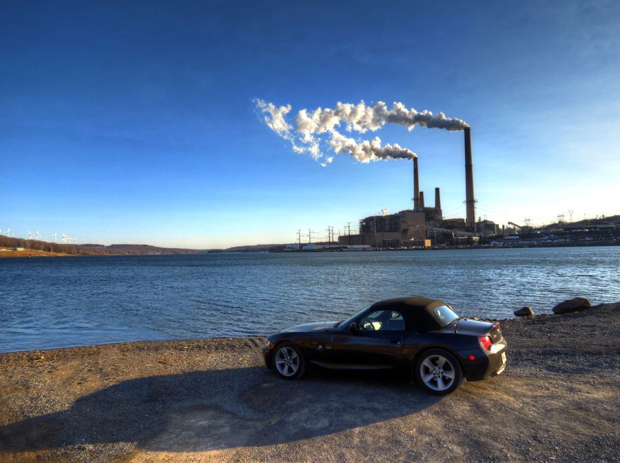
I'd previously visited Mt. Storm Lake on a motorcycle journey with The Intrepid Buzz. The lake serves as a cooling source for the coal-fired power plant here. Such are the cooling needs that the entire lake is cycled through the power plant every 2 1/2 days! And even in the dead of winter, the water temperature generally remains above 50 degrees. Ironically, the electricity generated here in West Virginia is sent off to meet the needs of Northern Virginia.
Did I mention the snow? Despite the onset of Spring, I was finding many snow-covered places. Fortunately, the roads were clear and dry for the most part. As for the temperature, it had been declining steadily and was now only about 38 degrees.

I found Canaan Valley without difficulty and checked into a basic-but-comfy room for the night. I'd had a fun day of driving and exploring, with more to come the following day. It probably goes without saying, but the roads in West Virginia are a delight. Seldom level, seldom straight, and never ordinary. It's hard to imagine a more entertaining place to exercise a capable sports car. And although my Z4 is just the 3.0i model, the engine would still launch the roadster up even the steepest climbs as fast as I wished (and its brakes would quickly haul it back down as necessary for the next corner). That car just loves to run in the 4,000-6,500 rpm range, and it sounds great in the process.

With all the fun of my first day, I was looking forward even more to the second.
Rick F.