

| BMW Garage | BMW Meets | Register | Search | Today's Posts | Mark Forums Read |
|
|
|
 SUPPORT ZPOST BY DOING YOUR TIRERACK SHOPPING FROM THIS BANNER, THANKS! |
|||||||||
Post Reply |
|
|
Thread Tools | Search this Thread |
| 08-14-2010, 06:42 PM | #1 |
|
Lieutenant Colonel
 946
Rep 1,910
Posts |
A Z4 Tour of the C & O Canal
At long last, I got back on the road in the mighty BMW Z4 3.0i for further exploration and driving enjoyment. My destination on August 9 was several parts of the Chesapeake & Ohio Canal that I'd never been to before. As many of you probably know, the C & O Canal was built before railroads had established their ability to move goods quickly and efficiently. In the 1820s, a canal promised a much easier way to transport coal, timber, tobacco, and the all-important whiskey than hauling it over the mountains in wagons. Eventually, the C & O Canal connected Washington, DC and Cumberland, MD and featured over 180 miles of canal, 75 locks, and a 3,118-foot-long tunnel, carved by hand tools through solid rock. (All historic photos are courtesy of the Western Maryland Historical Library.)
 The Paw Paw tunnel, incidentally, took 14 years to complete. By the time it was done, the Baltimore & Ohio Railroad was well on its way to making the C & O Canal obsolete. The Canal operated, partially or wholly, from 1828 to 1924, but it was never a major financial success. Almost all of the canal is still in place today, although, as we'll see, some of the most interesting parts are deteriorating badly and may not last much longer. A fascinating silent movie from 1912 shows the canal in action. It's available in three 4-minute segments from the American Memory Project: C & O Canal film, Part I C & O Canal film, Part II C & O Canal film, Part III My first goal was to find the ruins of the Charles Mill, near Four Locks, MD. Naturally, I tried Charles Mill Road, which I figured would lead me right there. Along the way, I spotted the foundation of a mill, large house, or other building. "There's treasure everywhere!"  Investigating, I saw that there wasn't much left other than the foundation, which bordered on what appeared to be a mill race… 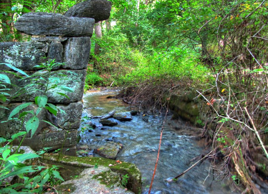 …and this not-so-trustworthy wooden bridge. 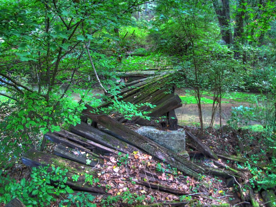 A little further along the road, I found this Ford sedan languishing in the woods. Okay, can anyone identify the model and year without seeing the grill??  As best I could tell, the Ford belonged to this property (or vice-versa):  The Charles family seems to be alive and well in this area, by the way, judging from the number of No Trespassing signs I saw with the name Charles on them. This farm, at least, seems to be doing much better than the others.  Eventually I reached the end of Charles Mill Road—and found an unoverlookable Do Not Enter sign on a private driveway. Dang! I decided to try my fallback approach to the mill ruins, starting from Four Locks and hiking a half mile or so on the canal towpath. As I drove to Four Locks, I passed by this intriguing gateway (and more No Trespassing signs—these guys have no sense of historic exploration).  Soon enough, with skillful navigation and several tries, I located the Potomac River. (It involved driving to the end of Four Locks Road and then stopping before falling into the river.)  Four Locks is so-named, naturally, because of its four locks on the C & O Canal, which carried barges up or down a significant vertical distance in a relatively short distance. This picture is taken looking through Lock 50 downstream toward Lock 49. Locks 48 and 47 are further down the hill.  Since the C & O Canal locks operated strictly through a gravity-flow basis, negotiating the four sequential locks apparently took a while—as evidenced by this waiting line.  Armed with my trusty Zumo GPS, I set off along the towpath to try and find the ruins of Charles Mill, a grist mill built alongside the canal. It turned out to be easy, thanks to a fading historical marker. There's not a lot left of the mill, but it was a haunting sight nonetheless.  So haunting, in fact, that I apparently tumbled down the bank and into the mill race, capturing this picture in the process.  Okay, I didn't really fall down the hill. But I did clamber around the end of the National Park Service fence that was designed to keep passers-by away from the mill ruins. Well, I had to get a good picture for you all, didn't I?? As I hiked back along the towpath, I spotted another building off in the distance and decided to investigate further. It involved climbing down the bank into the (dry) canal, crossing over the canal bed, and walking a little further into an overgrown field. There, in the distance, was this building, looking a bit forlorn and abandoned:  Remember the large abandoned gateway? I began to wonder whether it was associated with this abandoned building, which looked vaguely like a guesthouse. I decided to investigate. Moreover, as every good motorcyclist and Z4 driver knows, it's always best to take a different route back than the one you took to arrive. Having adequately justified a round of trespassing to myself, I waded through the field and arrived at the guesthouse. It was not fancy or even particularly old. It featured a very large letter "R" over the front entrance but was otherwise not as interesting as I'd hoped. As I anticipated, it had a much-overgrown dirt driveway in front, and I walked along it on my way back to civilization. The trip involved passing by another abandoned house, before arriving back at—yep—the abandoned gateway. All in all, a fun little off-course adventure. From there, I walked back along Four Locks Road to where I parked. This is a picture of the Lock 49 lockhouse, which is still there. You can even stay in it for $85 a night, courtesy of the National Park Service.  For some reason, I didn't get a "modern" picture of the lockhouse, but I did photograph this nice stone mansion, which is nearby. Four Locks used to be a thriving community during the canal's heyday, with numerous houses, businesses, and…  …this one-room schoolhouse.  Peeking through one of the dirt-streaked windows, I saw various old desks, chairs, and the Mother of All Stoves.  After one more picture at Four Locks (of the spillway for Locks 48 and 47), I hopped back in the trusty Z4 and continued on.  My next goal was one of the 11 aqueducts that carried the C & O Canal over various creeks and rivers. At 90 feet, the Licking Creek Aqueduct is the longest of the single-arch C & O aqueducts. Every one is a work of art, with impressive craftmanship. Most of them, however, have suffered badly through various floods and lack of repair. The 3-arch Catoctin Creek Aqueduct has collapsed completely, a victim of Hurricane Agnes in 1972. The stunning 7-arch Monocacy River Aqueduct was reinforced and rebuilt a few years ago and deserves a visit by anyone in the area. Fortunately, the one at Licking Creek was in reasonably good repair, having lost only its upstream wall.   A little farther north along the canal, the builders took advantage of a mile-long island in the Potomac River to create Little Pool. It's easy to reach by a series of stone steps, followed by a section of the ubiquitous shale rock formations.  And what a sight it is!  Locks 51 and 52 are near Hancock, MD. In the distance is a 1780 brick farmhouse, which has very recently been turned into one of the C & O Canal National Park visitor centers.  Did I mention that the temperature had risen to 95 degrees and that all this hiking around was wearing me out? I decided to stop in at the farmhouse and enjoy the exhibits there (not to mention the shade!) for a little while. The building was quite impressive and in excellent condition, thanks to the NPS restoration work.  It was built in about 1780 by the Yates family and named Sarah's Fancy. The Bowles family bought the farm in 1875 and realized that they had an "automatic" market for their produce. Before long, they became quite well-to-do and expanded the house to its current upscale configuration.  I learned most of this history from Ranger Samantha and volunteer guide Charlie, who were friendly and very generous with their time.  Although the other farm buildings are long gone, the original summer kitchen is still in reasonable condition.  Leaving the visitor center, I hiked along the towpath in search of the Little Tonoloway Creek Aqueduct. Along the way, there were numerous views of the Potomac. Notice the shale rock formations lying just below the surface in the foreground of this picture. Kayakers and rafters beware!  The Little Tonoloway Creek Aqueduct was easy to find but not in very good shape. Both side walls have washed away over the years, and the main arch is held together by iron straps, duct tape, and assorted band-aids. You might want to visit sooner, rather than later. Notice how the far end of the arch rests on an elevated stone outcropping and is thus much higher than the base on the near side.  Here's a vintage photo of the aqueduct in better days. I guess leaks were pretty common when stonework was used to contain thousands of gallons of water.  This close-up of the original railing shows the high quality of the workmanship. 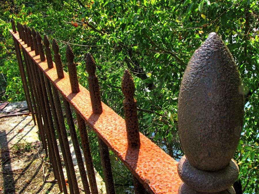 Now, as it happened, I had parked at the location of the old visitor center, having missed the sign for the new one (at the Bowles farmhouse). I had hiked a good three-quarters of a mile downstream on the Western Maryland Rail Trail to reach the new visitor center and then a ways upstream on the towpath to the aqueduct. At this point, I was pretty worn out, and I decided to stick to the towpath back to the parking lot, in hopes of shortening my return trip. Of course, I was aware that the canal itself—steep banks and all—was now between me and the parking lot… As I wandered along, I spotted these ducks who seemed to prefer a hot old rock to the nice cool Potomac River. Go figure.  Walking along upstream, I was beginning to despair of finding a viable way back across the canal to where I'd parked. Eventually, however, I saw that the near bank could be descended without too much difficulty and that the far bank was only 20 or so feet high—much better than the towering climb that would otherwise be required. So, down I plunged, taking the opportunity to get this picture of the bed of the canal. (The canal has been "rewatered" in a few places. Thankfully, this wasn't one of them!)  Well, getting up the far bank was still a pretty good adventure, but with feet sliding and scrabbling all over the place, I managed to grab various saplings and branches, plough through some of the thickest spiderwebs I've ever seen, dodge the poison ivy, and eventually end up at the top—right on the Rail Trail and only a quarter mile from the parking lot!  My adventures were not over for the day, however, as I next set off to find Cacapon Junction, MD and the Sideling Hill Creek Aqueduct. The roads were initially well-paved and very entertaining, with numerous bends and elevation changes—the perfect setting for a capable sports car like the Z4. However, I suspected that my path would subsequently involve some Questionable Dirt Roads, and I was not mistaken. This section of the road was typical (but not really all that bad):  As I drove along this road, I lost reception for the station I'd been listening to, so I scanned for another. As the next one tuned in, I realized that it was the Diane Rehm show on NPR—and that they were talking about me! Here I was, trying to escape the hustle-bustle of my job by going for a drive in the middle of nowhere… It was a downright odd, if not surreal, experience. If anyone's interested, the show is available here: The Diane Rehm Show: The Future of Entitlements As if hearing myself talked about on the radio (sometimes favorably, sometimes less so) wasn't scary enough, next I happened across this place!  As the dirt road wound around corners and up and down hill, there were occasional scenic vistas. At one point, I found myself looking down at an evaporating pond, populated by a solitary waterbird.  After driving by, I had a moment of sudden recognition—could that have been a Great Blue Heron in the pond? They are notoriously private birds, and it's rare to see them. I carefully reversed back up the hill and, sure enough, there he was.  The dirt road continued for a number of miles, passing by Cacapon Junction in the process no doubt, although I saw no signs of it (whatever it is—it was listed in my C & O Canal book). Before long, however, I spotted a large, collapsing building down another dirt road.  As it happened, this dirt road continued a bit further and ended right at Lock 56. A passing park ranger told me that the Sideling Hill Creek Aqueduct was just another half mile or so upstream, so this was a convenient break. Here's the basin, lock, and lockhouse on the day that I visited…  …and here's one of the water gates to Lock 56, tended by the lockmaster and his family. To quote from the Western Maryland Historical Library's caption for this picture, "Photograph of Thomas Donegan, Ann Gotner, and Anna Kent resting on a swing beam of a lock gate. Thomas Donegan was a canal boatman before settling down at lock 56. He built a large house there and raised 13 children." (Sly old dog!)  Here's one more picture of Lock 56, featuring a rather dusty Z4.  After hiking yet another half mile in the blazing heat, I reached Sideling Hill Creek, shown here emptying into the Potomac.  Looking upstream along the creek, here's one of the B & O railroad bridges that helped doom the canal to historical oblivion. (Boo! Hisssss!)  My vantage point for both of the prior pictures, of course, was the aqueduct itself. Here's a vintage photo of it, apparently during a significant flood.  And, Faithful Readers, just for You, I clambered down one more steep embankment and hiked (yet another) quarter mile down the creek to get this current-day picture of the Sideling Hill Creek Aqueduct. It, too, is being held together with the proverbial duct tape. I hope some of the free-flowing American Recovery and Relief Act funding can find its way to these aqueducts, before all that's left are the photos.  In view of the late hour and my state of fatigue, I took some entertaining back roads up to Interstate 68 and slabbed it on home. I missed the last fifth or so of my planned route, but I'll be back! Rick F. Last edited by Rick F.; 09-22-2015 at 01:38 PM.. |
| 08-14-2010, 08:53 PM | #2 |
|
Iron Ring

11
Rep 316
Posts |
Thanks for the tour!
Incredible voyage with lots to see! Great photos.
Amongst my photos I have a winter photo of Chaffeys Lock, in Ontario Canada. A little history...Chaffey had a mill. Colonel By built the Rideau Canal. There's a single lock, still in use. Chaffeys Lock. Nearby on another road (Jone's Falls Road) there's a sign identifying "California" Ontario. It's on maps. There are no buildings, except a church and one room school a mile or so away. Chaffey went to California. He's founder of Ontario California. Top of the lock, looking downstream to Lake Opinicon... 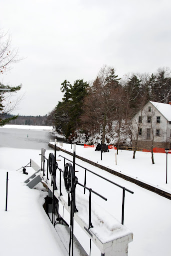 Looking upstream... 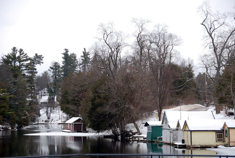 Rideau Canal is still in use! We're very lucky it has been preserved. Thanks so much for your post. Wish I could buy the book! DaveLynch Last edited by DaveL--2mnycars; 08-14-2010 at 08:57 PM.. Reason: Sometimers |
|
Appreciate
0
|
| 08-14-2010, 11:33 PM | #3 |
|
First Lieutenant
 
21
Rep 352
Posts |
Rick,
You do know that all of that exercise you got will keep you young... Looks like you probably put on as many miles walking as driving, and other than the hot temps it looks like you had another great day. Okay I'll take a stab at the car, '65 Ford Fairlane? It's really neat to see that the locks are still in fairly good shape, are any of the surviving lock areas considered a state sanctioned Historical site? (Protected?) I saw a couple of items I would be interested in with the picture you took of inside the one room school house... the wood stove of course, and that drafting table! The house you saw after finding the NPR program on your radio, is a perfect set for a horror movie. You didn't happen to walk around it and peak in, it's kind of a freaky looking place.   Awesome Trip...! Awesome Trip...!Dave
__________________
 OEM Strut Brace / UUC SSK / Zeck CDV / Clutch Stop / ZHP Shift Knob / Stubby Ant / Top Covers / Dinan K&N / M Seats / SP / PP |
|
Appreciate
0
|
| 08-15-2010, 09:31 AM | #4 |
|
Certified Adrenaline Junkie
41
Rep 1,325
Posts |
Great photos Rick! I grew up in Northern Virginia and we would ride our bikes along the C&O. Brings back some good memories. I'm not versed in cars older than the 80s but that looks like a Thunderbird. I have no idea on the year unless I ask my good friend Google. If I had to guess, I'd say 67. Very cool learning the history of the C & O. I never knew what it was for. That picture of you tumbling down the hill is really cool. Looks like it is moving.
|
|
Appreciate
0
|
| 08-15-2010, 02:23 PM | #5 | |
|
Lieutenant Colonel
946
Rep 1,910
Posts |
Quote:
It's fascinating to see how local historical figures end up moving around the country and accomplishing things in many areas, such as your example of Chaffey first building a mill in Canada and later founding Ontario, CA. In the back of my mind, I had always wondered how it got its name. Nice pic's, by the way! Rick |
|
|
Appreciate
0
|
| 08-15-2010, 03:01 PM | #6 | |
|
Lieutenant Colonel
946
Rep 1,910
Posts |
Quote:
You're right about the exercise. It was a good workout and much-needed. Regarding the car, my first guess was a 1966 Fairlane. After some Internet research, however, it turns out to be (drumroll, please) a 1965 Ford Custom 500 2-door sedan. It's a close cousin of the Galaxy 2-door hardtop, which is also a close cousin of a '65 Fairlane 2-door. The entire C & O Canal area is a national park and thus protected. (See http://www.nps.gov/choh/index.htm.) Some of the areas have been kept up beautifully or restored, while others are well off the beaten path. A nice (scalable) map of the entire park is available at http://www.nps.gov/choh/planyourvisi...ad/parkmap.pdf. As for that gigantic stove, I wonder if it was original to the schoolhouse? It looked fairly large for a relatively small building, so it may have been moved there as part of a renovation effort. Good luck getting it into the trunk of your Z4! I was tempted to look inside the abandoned house, but I once had a fairly unsettling experience doing that. These days, I mostly look through windows. This one definitely had a high Freak-Out Quotient.  Rick |
|
|
Appreciate
0
|
| 08-15-2010, 03:05 PM | #7 | |
|
Lieutenant Colonel
946
Rep 1,910
Posts |
Quote:
Glad you liked the pic's. Regarding the car, per my note above, it's a '65 Ford Custom 500 2-door sedan. The Thunderbirds of the day were quite a bit swoopier, and all of them were 2-door hardtops or convertibles. (And yes, I had to ask my friend Google about the exact identification. It's nice that we have a friend in common!) Regarding my "moving picture," I'm not sure how I ended up with it. I must have accidentally pressed the shutter while I was lowering the camera and turning away from the mill ruins. Mostly I liked its psychedelic effect. Rick |
|
|
Appreciate
0
|
| 08-15-2010, 03:41 PM | #8 |
|
Dog Listener
701
Rep 7,850
Posts |
Wow, as usual, a wonderful set of photos and history to go along with them! Thank you for sharing these!
I find it striking how changes in technology and other economic forces have driven areas through cycles of expansion, success, and eventual decline as newer technology comes on this scene. These cycles seem to come up a lot in the history behind the pictures....and as we see today with technology and other economic forces pushing jobs overseas, these cycles continue and are a driving force in human history.... The way nature takes back over quickly is fascinating. In some ways the photo shoots remind me of detailed view of "Life After People". In any case, thanks for taking us along with you as the shots and story are both beautiful, entertaining, and educational! |
|
Appreciate
0
|
| 08-16-2010, 03:29 PM | #9 | |
|
Lieutenant Colonel
946
Rep 1,910
Posts |
Quote:
Thanks for your interesting insight regarding history and technological change. And thanks, too, for the fascinating website with its assessment of how various buildings and other famous objects will fare "after people." Really well done. Rick |
|
|
Appreciate
0
|
Post Reply |
| Bookmarks |
| Thread Tools | Search this Thread |
|
|


