The next day I was greeted by a handsome sunrise, a nice view over Canaan Valley, and a temperature of 22 degrees! The lodge restaurant served up an excellent and inexpensive breakfast of scrambled eggs, bacon, hash browns, and biscuits. I chatted with some good-old-by-God-West-Virginia fellows at the next table and reviewed my route. What a great way to begin the day.

West Virginia offers scenic vistas almost everywhere, often accompanied by rustic old barns or houses. And Highway 72 was a real treat, with countless switchback corners and something interesting around every one. The elevation would approach 3,000 feet in places, only to plunge back downhill to 2,000 feet or so. Very entertaining, although careful concentration was required: the road was narrow, with many blind corners, and pickup trucks were not uncommon.


Small hillside farms would often appear, even in the remotest of locations. The Walnut Hollow Farm was the only sign of civilization that I saw for miles as I motored on toward Parsons, WV.

When you stop for a photo in West Virginia, it's advisable to set that parking brake really tight!

Following one of the seemingly vertical descents, the road paralleled the Dry Fork River for quite a while. It seemed to have plenty of water. The stream is popular with white-water canoers and kayakers willing to tackle its challenging Class III rapids.

Have you ever looked out your passenger window and discovered that it's pouring rain, but only on that side of the car? That's what happened to me…

…or so it seemed. Turned out I had parked next to a small waterfall. Too busy keeping my eyes on the road, I guess!

At Hendricks, the Dry Fork joined forces with the Blackwater River to form the Black Fork River. (I suppose they could have called it the "Dry Water" River instead, at the risk of being oxymoronic.) At Parsons, the Black Fork and Shavers Fork Rivers combine to create the mighty Cheat River, one of the most exciting, challenging, and potentially dangerous rivers in the country. Accounts vary, but the most popular story behind the river's name has to do with the number of people "cheated of their lives" by its treacherous rapids and whirlpools. (My Dad, being something of a reckless explorer in his own right, canoed the Class IV Cheat River Canyon several times.)
Parsons features an historic old railroad station (even though the tracks have long since vanished)…

…the spectacular Tucker County courthouse and jail…

…and Corrick's Ford across the Cheat, just outside of town. In July 1861, Union forces under Gen. George McClellan finished off the fight with Confederates that had started at Philippi (the first land battle of the Civil War) and that had continued at the Battle of Rich Mountain. The Confederates were outnumbered by more than four to one, and their commander Robert Garnett became the first General to be killed in the war. The success of this campaign prompted President Lincoln to appoint McClellan as the commander of the Army of the Potomac.


The full
RoadRunner magazine route goes as far west as Weston, WV—home of the fearful Trans-Allegheny Lunatic Asylum. Since I only had 2 days, I took a shortcut to Elkins that bypassed Philippi, Weston, and Buckhannon. However, if you're ever in the area, the Asylum is not to be missed. My wife Nancy and I visited there in 2011. It was closed for the winter, but we managed to join a privately scheduled tour for a Canadian school group. Here are a few photos from that trip to give you a sense of the place. And no, I can't explain all of them…


Okay, I suppose the last one should be explained. Our tour guide, who had worked at the asylum as a nurse, asked if any of the students wanted to leave this room before she graphically described the
murders committed there. There was quite a migration for the door, and an excessive dose of HDR processing adds to the drama, don't you think? Oh, and the earlier picture of the slightly transparent fellow at the end of the hallway? I thought I was taking a photo of an empty hallway…
Anyway, you should plan on visiting there sometime (preferably during daylight hours!)
Compared to the Trans-Allegheny institution, the city of Elkins was pretty ordinary. Just for Cathy and Kim, here is a Scenic Baptist Church—on the left. The other one used to be Saint Brendans Catholic Church; now it's the Randolph County Community Arts Center.

The 1902 Randolph County Courthouse is even more impressive than Tucker County's. The smaller building to the right is the County Jail.

The last time I had been in Elkins was as a 17-year-old, visiting colleges. (Yes, Willis, they
had colleges back then…) Davis & Elkins College has operated since 1904—without me, as it happens, since I ended up at the College of Wooster in Ohio. The Gatehouse is one of the oldest buildings on the campus.

Why does a college have a gatehouse? Mostly because the gatehouse originally served the summer mansions of Senator Henry G. Davis and his son-in-law Senator Stephen B. Elkins. This is Senator Davis' Queen Anne style home, Graceland, built in 1893 and named after his youngest daughter. When the Davis family donated their home to the college, it was used as a dormitory for 30 years. For some reason, it required extensive renovation after that, and it's now a beautiful inn.


Senator Elkins' home is called Halliehurst, after his wife and their youngest daughter. It now houses administrative offices for the college.


Next up was the site of the Battle of Rich Mountain, which, as noted above, was a follow-up to the Battle of Philippi. Believe it or not, this road was the original Staunton-Parkersburg Turnpike. A portion of Gen. Garnett's Confederate forces, led by Lt. Col. John Pegram, were spread out along this important thoroughfare in an effort to prevent the Union Army from gaining access to it.

Union Gen. William S. Rosecrans led his brigade up a mountain path and attacked Pegram's forces from the rear on July 11, 1861. In this photo, imagine yourself in the foreground as a Union soldier, attacking up the hill to where the Confederates were positioned in a stable yard (where my Z4 is parked). The southerners had only a single cannon to defend their position. Between the surprise attack and their superior numbers, Gen. Rosecrans' men managed to split the Confederate force in two, capturing half of them and driving the rest down Rich Mountain to the town of Beverly. The final skirmish at Corrick's Ford came 2 days later, and the Union victory consolidated their hold on northwestern Virginia—which subsequently seceded from the Confederacy and became the State of West Virginia. Lt. Col. Pegram was among the captured; he was subsequently exchanged but died at the Battle of Hatcher's Run in Virginia in 1865.


Speaking of the town of Beverly, this was the home of one Laura Jackson Arnold—the sister of Thomas "Stonewall" Jackson. She was an ardent Unionist, however, much to the despair of her brother, not to mention her southern-leaning husband who remarked that "my wife is crazy, but Hell could not govern a Jackson." Laura cared for wounded Union soldiers during their occupation of Beverly.


Continuing on through the Tygart River Valley, I came to Mill Creek.
Some of the houses here were in better shape than this one…

I was looking for the 1898 E.E. Hutton house in Huttonsville (naturally), but it took some doing. I finally discovered it perched a good 65 feet above the road. Undaunted, the faithful Z4 charged up the steep and rocky drive, saving me from a 6-story climb! In case you were wondering, the "E.E." stood for Eugene Elihu." His great-grandfather, Jonathan, settled Huttonsville in 1795 and lived in a log cabin on the same site as the current house. (It was burned by Union troops in 1861.) E.E.'s Victorian house has more than 40 windows, and the interior is still lit by gas lamps. It operated as a bed & breakfast in the recent past, although no one seems to live there currently.

At Huttonsville, I continued on the path of the current Staunton-Parkersburg Turnpike by taking Highway 250. I soon found myself driving up Cheat Mountain, and two things quickly became apparent: First, the snow on the sides of the road was getting deeper and deeper, and second, the temperature was dropping steadily. At an elevation of almost 4,000 feet, the snowbanks were more than 4 feet deep, and the Z4's outside thermometer read 36 degrees—and since the top was down, I was pretty much "outside." I didn't dare stop to put the top up, however, because I had managed to pass a slow-moving truck and five trailing cars a couple of miles back, and I was thoroughly enjoying the twisting climb up the mountain. No way did I want to fall behind the moving roadblock again! I did, however, resort to putting my gloves on…
The town of Cass, WV is well-known to sightseers and train enthusiasts everywhere—but have you ever heard of nearby Durbin? Seeing a sign for the "Durbin Rocket," I stopped to investigate. I found the station, tracks, and scenic tour train cars, but alas the 1910 Rocket—one of only three existing steam locomotives of its type—had wandered off. However, I found it among the beautiful photographs at
Scriptunas Images. Looks like fun! The switches and tracks are left over from when former Senators Davis and Elkins extended their Western Maryland Railroad to Durbin in the early 1900s.


I found this once-elegant home in Bartow. And while I was there, I gave up and raised the top.

As the day wore on, it occurred to me that I'd never had lunch. Watching Lamb and Mom made me all the hungrier—but I draw the line at warm goat's milk! (I had a glass of warm goat's milk in 1988 in the People's Republic of China; it would have been barely tolerable if not for the lumps…)

As with the town of Cass, almost everyone has heard of (and many have been to) Seneca Rocks. But how many of you have heard of Nelson Rocks? They're another set of "razorback" cliffs, only a stone's throw from Seneca Rocks, and I was determined to locate them. Determined enough, in fact, to take this narrow, muddy road straight up yet another mountain.

After a few miles, I suddenly realized that I was driving in-between two gigantic, narrow ridges of stone. My photos don't begin to do justice to the majesty of these peaks.


To give you a better sense of the breathtakingness of these ridges, I've added an aerial photo (courtesy of the
Nelson Rocks Outdoor Center). And, yes, on the left that's a
rope bridge from one ridge across to the other. It's 200 feet long and 150 feet high, and the rest of the Center's mind-boggling Via Ferrata Tour looks way scarier. Talk about reckless exploration! Or you can take the Center's Canopy Tour and spend more than a mile in the air on ziplines as high as 80 feet above the ground. (Okay, where do I sign up?)

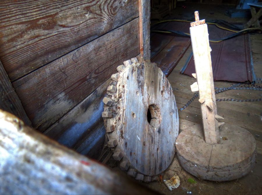
A little farther north, I managed to find Bogg's Mill on only the third try. It was built in 1830 and, remarkably, was in operation as recently as 1966.


Apparently George Washington wasn't the only one to have wooden teeth…

North of Petersburg, WV sits a magnificent brick farmhouse from about 1830 known as "The Manor." This is as close as I could get to it without making a complete nuisance of myself, and it's quite a place. The nearby log structures are former workshops and slaves' quarters, although I believe they are not original to this property.


From Moorefield, WV, the quick way back east is via the new West Virginia Highway 55. But the fun and scenic way is to take Old Highway 55. For example, would you rather be one of the little cars up on the Highway 55 bridge shown in this photo, or would you enjoy driving directly alongside the Lost River? In the summer, incidentally, the Lost River disappears below ground a few miles downstream of this photo. It re-emerges a couple of miles later as the Cacapon River. On my visit, there was still enough snow runoff to keep the Lost River above ground.

Oh, and you find more scenic vistas on Old Highway 55 as well!

By now I was once again hopelessly behind schedule, and it was starting to get dark and threatening to rain. Needing to make time, I nonetheless decided to turn off on an interesting-looking old dirt road, just to see where it went. (I recognize that this is a form of mental illness…) Sure enough, it proved to be scenic both for its old houses and the occasional derelict 1956 Ford sedan. In West Virginia, there's treasure everywhere!


Cedar Creek must have been formed during the last ice age, as there are large boulders strewn throughout its path.

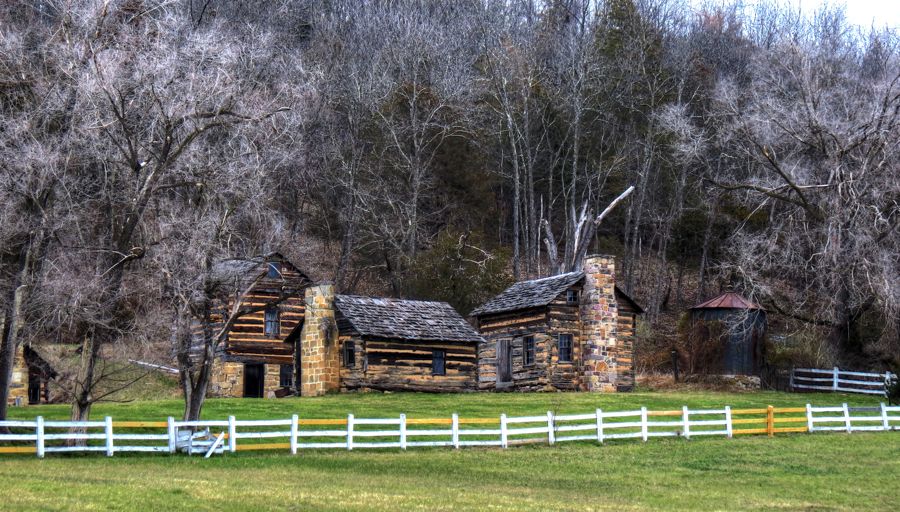
Just next to the creek, I ran across this old-looking house. Subsequent research indicates that it is the Old Forge Farm, which included the Zane Iron Furnace / Marlboro Iron Works near Marlboro, Virginia. The 1750s part of the house is on the right and has limestone walls that are nearly 2 feet thick; no wonder these old places last a long time. The smaller part on the left was added in the early 1800s. An earlier archaeological dig identified a Native American village on the property, dating back to the Middle Archaic and Late Woodland Periods (5000 BC to 1600 AD.

I was struck by the unusual, hexagonal building across from the farm house. It proved to be an ice house and—more interestingly—"Stephens Fort." Its lowest floor is 19 feet below ground level, and the original builder, Lewis Stephens, used it to provide protection for his family and neighbors during Indian raids. Isaac Zane bought the property in 1767, including its ironworks, and became one of the largest producers of munitions for the Continental Army during the Revolutionary War. The Army did not pay Zane for much of the ammunition he supplied; the ironworks was in ruins by 1783, and, financially, so was Zane himself.

Imagine, all that history associated with an unassuming little farm that I glanced at, took a photo of, and thought little about at the time. Golly!
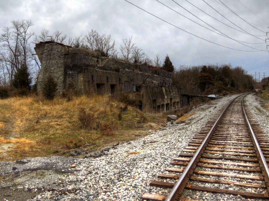
While loitering on some railroad tracks just outside of Stephens City (yep, named after Lewis Stephens), I happened to notice a humongous pile of limestone ruins. Ignoring the setting sun, schedules, and any sense of where I was supposed to be, I wandered over to investigate. As best I could tell, this used to be a massive furnace for producing coke. (Uh, that's coke as in coal baked at a high temperature for purification, with the results used in the production of steel…) I didn't count them, but there were dozens of these ovens incorporated within the structure.

We've all seen lots of three-wheeled motorcycles, or "trikes," but what do you make of
this one?? It's powered by a Chevy V-8, and while the front wheel has twin brake rotors, there are no brake calipers fitted. It was the only thing I saw on this trip that is even scarier than the Trans-Allegheny Lunatic Asylum.

Several trips ago, I had intended to search for the ruins of a mill rumored to sit alongside the Shenandoah River near the historic Hopewell Farm. I'd been to this vicinity before, on a motorcycling trip with my buddy Tim Love (see
SRR 2008 Scenic Tour). We'd stopped to admire Little's Falls where the river abruptly drops several feet, but at that time I had no idea that there might be an old woolen mill nearby. By the time I returned on my current trip, the sun had already set, and I cast about in the gathering darkness, looking for any ruins.

I found an obscure path, crossed by fallen trees, vines, and large rocks, and of course decided to give it a try. Before long, I found possible evidence of a mill stream with man-made stone reinforcing walls. In the darkness, it was kind of hard to tell.

Thinking that these were probably the only ruins left, I almost turned around to hike back to the Z4 before it got completely dark. As usual, I had no flashlight—or, for that matter, common sense—and I continued on. (Maybe there's still a little "reckless exploration" left in me.) Eventually I was rewarded by this massive, three-story stone wall that once formed part of the 1850 woolen mill! Ironically, the sole remaining wall is the one that directly borders the river. The other three have long since been washed away by floods. This woolen mill was the largest one along the Shenandoah River and continued in business through about 1920, mostly producing uniforms for the U.S. Army.

I was so tickled to find this ruin that I practically floated over the various obstacles in the darkness on the way back to the car. With a quick photo of the 1765 Hopewell farmhouse, I was on my way home.

Except, naturally, for a brief stop to see the Allstadt House and "Ordinary" (tavern). Driving in the dark as I was, I went right by the ruins of John H. Allstadt's original farmhouse without noticing. (Just another reason to go back.)

Thankfully, the historic site was illuminated by spotlights. The Allstadt house (on the right) was originally built in 1790 and sold to Jacob Allstadt in 1811. Jacob added a second story in 1830, along with the stone ordinary on the left. By October 16, 1859—the start of John Brown's raid on Harpers Ferry—Jacob's son John was living in the Allstadt house with his family, including 18-year-old John Thomas Allstadt. A detachment from John Brown's raiders had been sent to take important hostages. Their first stop was at the nearby Beall Air mansion, the home of Col. Lewis W. Washington, who was George Washington's great-great-nephew (see
West Virginia and the Legend of Wizard Clip. Charles and three slaves were taken captive, and the raiders next went to the Allstadt home, seizing John, John Thomas, and seven slaves. All of them were held within the Harpers Ferry firehouse, where we started this trip, and all survived the ensuing battle. When John Thomas died in 1923, we was the oldest survivor from the raid on Harpers Ferry. The Allstadt House and Ordinary have been restored to their appearance in 1859 and are open to the public.

In this
Harper's Weekly engraving of the scene within the firehouse, the younger fellow on the left is John Thomas Allstadt.

From the Allstadt House, it was an easy hour's drive back to Catonsville. All told, I covered about 500 miles during the 2-day tour, excluding my drive to and then from Harpers Ferry. It was great to see the Polimenis, fun to meet some new folks along the way, and a thrill to exercise the Z4 on some outstanding mountain roads throughout the trip. And talk about history around ever corner! I couldn't have asked for more.
Rick F.